B7054
| B7054 | ||||
| Location Map ( geo) | ||||
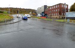 | ||||
| The modified junction at the east end of the road at the B788 Baker Street/Ingleston Street | ||||
| ||||
| From: | Inverkip Road (NS261755) | |||
| To: | Ingleston Street (NS282755) | |||
| Via: | Drumfrochar | |||
| Distance: | 1.5 miles (2.4 km) | |||
| Meets: | A78, B788 | |||
| Highway Authorities | ||||
| Traditional Counties | ||||
| Route outline (key) | ||||
| ||||
For the former B7054 in central Greenock, see B7054 (Greenock Centre).
The B7054 is a short route skirting the southern edge of Greenock. It was unclassified for many years but gained its number in the early 1970s, between 1972 and 1976.

The route starts at the Barrs Cottage Roundabout on the A78 near the prison, where it is signed merely as "Local", and briefly heads south east before curving towards the east along the residential Dunlop Street. The prison is hidden behind houses to the left, and a little further along the modern Notre Dame High School is passed on the right. A signalised crossroads on a fairly steep hill, with Peat Road and Murdieston Street just north of Drumfrochar station sees the route continue along Cornhaddock Street. Mid 20th Century council built houses line this long straight road at first, with a school in a gap to the north. A gentle descent brings the route to another signalised crossroads, with Drumfrochar Road, along which the B7054 then continues ahead. After a line of flats on the left, much of the residential part of Drumfrochar Road has undergone a major regeneration project in recent years which has resulted in the clearance of many older flats and houses on both sides of this stretch of the road, leaving grassy greens which are fenced off and uncared for.
As the route continues east, things seem to get worse as it enters an area of industrial dereliction, where brownfield sites stand open or concealed behind the remaining walls of the long demolished Tate & Lyle sugar refinery complex. After crossing over a railway line, the sharp left-hand bend at the junction with Baker Street was removed in 2019, replaced with a gentler curve giving views of the Firth of Clyde ahead. However, the route still ends at the next junction, which was also rebuilt, where the B788 comes in from the right at traffic lights and takes on the road ahead.


