C89 (Eilean Siar)
Jump to navigation
Jump to search
| C89 | ||||
| Location Map ( geo) | ||||
 | ||||
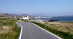
| Heading towards Eriskay and Ludag Pier | ||||
| ||||
| From: | Kilbride (NF747148) | |||
| To: | Ludag (NF776139) | |||
| Distance: | 2 miles (3.2 km) | |||
| Meets: | B888 | |||
| Highway Authorities | ||||
| Traditional Counties | ||||
| Route outline (key) | ||||
| ||||
This article is about the Class III road numbered C89 maintained by Comhairle nan Eilean Siar.
For other roads numbered C89, see C89.
For other roads numbered C89, see C89.
The C89 runs along the southern coast of Uibhist a Deas (South Uist), starting near the end of the B888 and heading east through Kilbride to the pier at Ludag. This used to be the ferry pier for Eriskay, but with the coming of the Eriskay Causeway, the ferry sails no longer. It is not clear if the C89 has been extended across the causeway or not.
| C89 (Eilean Siar) | ||||
| ||||
| ||||
|


