R171
| R171 | |||
| Location Map ( geo) | |||
 | |||
| R171 heading towards Dundalk | |||
| |||
| From: | Ardee (N959916) | ||
| To: | Dundalk (J046070) | ||
| Via: | Louth | ||
| Distance: | 20.9 km (13 miles) | ||
| Meets: | N2, N33, R166, R178, R215 | ||
| Highway Authorities | |||
| Traditional Counties | |||
The R171 in County Louth connects Ardee to Dundalk. Running via Louth village and Tallonstown, it follows a slightly longer route between the two towns than does the N52 via Readypenny. The route originally started 1Km south east of Dundalk at the junction with the N52, but when the N52 was rerouted in 2005 the R171 was extended to Dundalk town centre along the former N52 route, although the junction priority remains for the former N52 route.
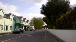
From the junction with former N52, the R171 initially follows a broadly straight route heading in a south westerly direction. It heads underneath the M1 as an S2 with no footway until we reach the village of Knockbridge. After passing through the centre of the village the road becomes more rural in character, with fewer houses and more bends, until we reach Louth.
The route is of moderate quality between Dundalk and Louth and is rather narrow and poorly aligned between Louth and Tallonstown, which also features a crossroads with poor visibility and North American style stop signs on all approaches to the junction (Mullacrew Cross Roads). Signposting actually directs northbound traffic from Tallonstown to Louth away from this poor section along local roads. In the picturesque village of Tallonstown the route passes over a narrow single lane bridge over the river Glyde and turns left at a TOTSO at the village crossroads. The section from Tallonstown to the junction with the N2 north of Ardee is relatively well aligned with the 80 Kmh speed limit possible in most sections.


