Star.pngStar grey.pngStar grey.pngStar grey.pngStar grey.png

Dundalk

From Roader's Digest: The SABRE Wiki
Jump to navigation Jump to search
DUNDALK
Dún Dealgan
Location Map ( geo)
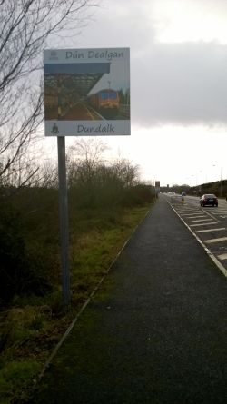
20160130-1526 - Dundalk Gateway Sign - 54.0156398N 6.3884737W.jpg
Dundalk gateway sign
Cameraicon.png View gallery (46)
County
Louth
Highway Authority
Louth County
Forward Destination on
M1, N1, N53, (A1)
Next Primary Destinations
Belfast • Newry
Other Nearby Primary Destinations
Armagh
Next Terminal & Intermediate Destinations
Castleblayney • Drogheda
Nearby Terminal & Intermediate Destinations
Ardee

Dundalk is a town (2011 Pop 37,816) in County Louth, Ireland, close to the border with Northern Ireland.

The town originally developed as a port around the Castletown River, and is around half way between Dublin and Belfast on the route of the former N1. The town centre is bypassed to the east by the N53, which since 1996 has provided access to the port and acts as an urban distributor, and to the west by the M1 bypass, which opened in the 2000s.

Routes

Route To Notes

M1

Áth Cliath / DUBLIN

Droichead Átha / DROGHEDA

N1

Béal Feirste / BELFAST

An tIúr / NEWRY

becomes A1

N53

Muineachán / MONAGHAN

Baile na Lorgan / CASTLEBLAYNEY
Baile Mhic Cullach / CULLAVILLE

becomes A37 when it briefly crosses the border

R132

Droichead Átha / DROGHEDA

Baile an Ghearlánaigh / CASTLEBELLINGHAM

R132

Gleann na bhFiach / RAVENSDALE

R171

Droichead an Chnoic / KNOCKBRIDGE

/ LOUTH

R172

Na Creagacha Dubha / BLACKROCK

R173

Cairlinn / CARLINGFORD

An Grianfort / GREENORE
Baile Mhic Scanláin / BALLYMASCANLAN

R177

Ard Mhacha / ARMAGH becomes A29

R178

Carraig Mhachaire Rois / CARRICKMACROSS

R215

An Muileann gCearr / MULLINGAR

Baile Átha Fhirdhia / ARDEE

Former route numbers

Route To Notes

N52

An Muileann gCearr / MULLINGAR

Baile Átha Fhirdhia / ARDEE

Dundalk section officially detrunked but still signed as N52

T1

Áth Cliath / DUBLIN

Droichead Átha / DROGHEDA

T1

Béal Feirste / BELFAST

An tIúr / NEWRY

T9

An Muileann gCearr / MULLINGAR

Áth Fhirdhia / ARDEE

T22

Muineachán / MONAGHAN

Baile na Lorgan / CASTLEBLAYNEY
Baile Mhic Cullach / CULLAVILLE

T23

Ard Mhacha / ARMAGH becomes A29

T24

Carraig Mhachaire Rois / CARRICKMACROSS

T62

Cairlinn / CARLINGFORD

An Grianfort / GREENORE
Baile Mhic Scanláin / BALLYMASCANLAN


Links

Irish Independent


Dundalk
Junctions
Crossings
Roads
A1 (Northern Ireland) • A29 (Northern Ireland) • A37 (Cullaville) • E01 • E104 (Dublin - Killeen) • E118 (Old System) • E126 (Old System) • M1 (Republic of Ireland) • N1 • N52 • N53 • R132 • R171 • R172 • R173 • R177 • R178 • R215 • R934 • T1 • T9 • T22 • T23 • T24 • T62
Related Pictures
View gallery (46)
Along the R 173 (C) Robert Ashby - Geograph - 3511102.jpg20160130-1526 - Dundalk Gateway Sign - 54.0156398N 6.3884737W.jpg20160130-1517 - Road narrows - 54.0161001N 6.3796096W.jpgEnd of the M1 - Coppermine - 3602.JPG20190820-1836 - St Johns Bridge across the Castletown River 54.026131N 6.429025W.jpg
Destinations in the Republic of Ireland
Major CitiesCork • Dublin • Galway • Limerick • Waterford
Terminal DestinationsArdee • Athlone • Ballina • Ballyshannon • Belturbet • Belview Port • Blackrock • Borrisokane • Cashel • Castlebar • Castleblayney • Cavan • Charlestown • Clonmel • Cork Airport • Dingle • Donegal • Drogheda • Dublin Airport • Dublin Port • Dún Laoghaire • Dundalk • Dungarvan • Ennis • Enniscorthy • Ennistimon • Foxford • Kenmare • Kilkenny • Killarney • Killorglin • Kilrush • Letterkenny • Longford • Malahide • Mallow • Mitchelstown • Monaghan • Mullingar • Nenagh • New Ross • Port Laoise • Rathcoole • Ringaskiddy • Roscommon • Rosslare Harbour • Shannon • Sligo • Stranorlar • Swanlinbar • Tallaght • Thurles • Tipperary • Tralee • Tullamore • Westport • Wexford
Intermediate DestinationsAn Clochán Liath • Athy • Ballyhaunis • Bangor Erris • Birr • Blessington • Cahersiveen • Carlow • Clifden • Dunfanaghy • Durrow • Foynes • Glenties • Kilkee • Listowel • Na Cealla Beaga • Navan • Roscrea • Skibbereen • Tuam
Other PlacesAbbeyleix • Arklow • Ashbourne • Athenry • Balbriggan • Ballaghaderreen • Ballinasloe • Ballincollig • Ballybofey • Bandon • Bantry • Blarney • Boyle • Bray • Buncrana • Bundoran • Buttevant • Cahir • Callan • Carrick-on-Shannon • Carrick-on-Suir • Carrickmacross‎ • Carrigaline • Carrigtwohill • Castlecomer • Castleisland • Castletownbere • Charleville • Claremorris • Clonakilty • Clones • Cloyne • Cobh • Collooney • Dunmanway • Edgeworthstown • Fermoy • Ferns • Glanmire • Glengarriff • Gorey • Gort • Granard • Inishcrone • Kanturk • Kells • Kildare • Kilmallock • Kinnegad • Kinsale • Kerry Airport • Knock Airport • Loughrea • Macroom • Manorhamilton • Maynooth • Midleton • Millstreet • Mountmellick • Naas • Newbridge • Newcastle West • Newmarket • Newmarket-on-Fergus‎ • Newport • Pettigo • Port of Cork • Rathkeale • Rosslare Strand • Shannon Airport • Slane • Sneem • Swinford • Swords • Tarbert • Tramore • Tullow • Wicklow • Youghal

SABRE - The Society for All British and Irish Road Enthusiasts
Discuss - Digest - Discover - Help