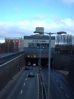
Clyde Tunnel
| Clyde Tunnel | |||||
| Location Map ( geo) | |||||
 | |||||
| From: | Whiteinch | ||||
| To: | Govan | ||||
| Location | |||||
| NS542664 | |||||
| County | |||||
| Lanarkshire | |||||
| Highway Authority | |||||
| Glasgow | |||||
| Opening Date | |||||
| 1963 (Northbound) 1964 (Southbound) | |||||
| Additional Information | |||||
| |||||
| On road(s) | |||||
| A739 | |||||
The Clyde Tunnel is actually two tunnels passing under the River Clyde in the west of Glasgow. Works started on 26 June 1957 and the tunnels cost £10.5m; construction used a tunnel shield based on Brunel's design. The first tunnel was opened for two way traffic on 3 July 1963 by Queen Elizabeth II, and the second tunnel opened on 23 March 1964 for dual carriageway operation. At the time it was the steepest road tunnel ever built, with a maximum gradient of 1:16 (6%). The first tunnel was 2500 feet long with a 22 foot carriageway.
Today it carries around 25 million vehicles a year. As with several tunnels, it is traditional for children riding in cars to hold their breath for the duration. The tunnel is not a trunk road, and is maintained by Glasgow Council. Unusually for a road tunnel, it is also open to pedestrians and cyclists, catered for with separate walkways under the road decks. In recent years the walkways have had access gates and CCTV added to improve pedestrian and cyclist safety - to gain access the person needs to push a button for the control room to open the gates.
The A739 runs through the tunnel; it connects to M8 junction 25 at the south end, while the north end of the road meets the A82 Great Western Road at Anniesland. The Kingston Bridge on the M8 is about 2 miles upstream, but (aside from the Renfrew-Yoker passenger ferry) it is much further to the next downstream crossing, the Erskine Bridge.
History
Before the tunnel was built, a ferry operated between Renfrew and Yoker. It provided a full 24 hour service, taking approximately 2 minutes to cross the River Clyde and carrying up to 18 cars at a time. In 1937 it cost 6d for a car to cross, rising to 1s 3d in 1963, just before the tunnel opened. From midnight until 5am double rates applied.
There was also another ferry service even closer to the site of the tunnel, operating between Whiteinch and Linthouse. This service ceased as construction works started.
Links
- Info from Glasgow Council
- Glasgow Motorway Archive: Clyde Tunnel
- Urban Ghosts: Enter the Clyde Tunnel’s Subterranean Pedestrian & Cycle Paths (17.04.2017)
| Clyde Tunnel | ||||||
| ||||||
|


