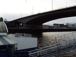
Kingston Bridge
| Kingston Bridge | |||||
| Location Map ( geo) | |||||
 | |||||
| The Bridge in January 2008 | |||||
| |||||
| From: | Anderston, Glasgow | ||||
| To: | Tradeston, Glasgow | ||||
| County | |||||
| Lanarkshire | |||||
| Highway Authority | |||||
| Transport Scotland | |||||
| Opening Date | |||||
| 1970 | |||||
| Additional Information | |||||
| |||||
| On road(s) | |||||
| M8 | |||||
The Kingston Bridge carries the M8, Glasgow's Urban Motorway, across the River Clyde just to the west of the city centre. It was opened on 26th June 1970 by the Queen Mother, so rapidly easing congestion in the city.
The bridge has five traffic lanes in each direction, but no hard shoulders. The two outer lanes south (west) bound are weaving lanes connecting the on and off slips either side of the river. On the north (east) bound side of the bridge, the two outer lanes are now segregated from the main carriageway, primarily to prevent the weaving movements. These two lanes are, despite not actually connecting to the rest of the M8 in any way, still apparently designated as part of the Motorway. This is presumably to prevent non-motorway traffic from using them. Of the 3 mainline lanes, the outer one departs on the north side, providing access to Bothwell Street (and merging with one of the outer lanes after the diverge from the M8!).
If all this sounds complicated, it is. To make things even worse, on either side of the river the bridge is supported on columns, with roads running underneath the motorway carriageways. On the north side of the river, it is the A804 that sits underneath, with parking in the central reservation, while on the south side it is the unclassified Brechin Road.
The M8 is always a very busy motorway, but at rush hour, the Kingston Bridge often becomes choked, partly due to the mass of sliproads on either side and the narrowing to two lanes to the north, but also because it is one of the easiest ways of crossing the river. With the M74 extension now completed, a substantial amount of through traffic may divert off the bridge, easing the flow. It is possible therefore that the current complicated lane layout across the bridge may change again in the future.
Links
| Kingston Bridge | ||||||
| ||||||
| ||||||
|


