Star.pngStar grey.pngStar grey.pngStar grey.pngStar grey.png

Durkar Interchange

From Roader's Digest: The SABRE Wiki
Jump to navigation Jump to search
Durkar Interchange
Location Map ( geo)
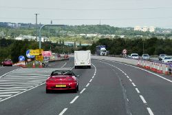
Northbound M1 at Junction 39 - Geograph - 4842340.jpg
Cameraicon.png View gallery (1)
Location
Durkar
County
Yorkshire
Highway Authority
National Highways
Junction Type
Roundabout Interchange
Roads Joined
M1, A636

Durkar Interchange is junction 39 of the M1. It opened in 1968.

Routes

Route To Notes

M1

Leeds

M1

London

A636

Denby Dale

A636

Wakefield


Durkar Interchange
Related Pictures
View gallery (1)
Northbound M1 at Junction 39 - Geograph - 4842340.jpg
Junctions on the M1
Marble Arch • Hampstead • 1 Staples Corner • 2 Fiveways • Scratchwood • 4 Brockley • Bushey • 5 Berrygrove • 6 Waterdale • 6A Chiswell • 7 Beechtrees • 8 Breakspears • 9 Friars Wash • 10 Pepperstock; (10A Kidney Wood) • 11 Junction 11 • 11A Chalton • 12 Toddington • 13 Ridgemont • 14 Broughton • 15 Collingtree • 15A Rothersthorpe • 16 Kislingbury • 17 Kilsby • 18 Crick • 19 Catthorpe • 20 Misterton • 21 Whetstone • 21A Kirby Muxloe • 22 Markfield • 23 Shepshed • Long Whatton • 23A Finger Farm • 24 Kegworth • 24A Warren Lane • 25 Sandiacre • M42 • 26 Nuthall • 27 Junction 27 • 28 Pinxton • 29 Heath • 29A Duckmanton • 30 Barlborough • 31 Aston • 32 Thurcroft • 33 Catcliffe • 34 Tinsley • 35 Thorpe Hesley • 35A Tankersley • 36 Birdwell • 37 Dodworth • 38 Haigh • 39 Durkar • 40 Flushdyke • Kirkhamgate • 41 Carrgate • 42 Lofthouse • 43 Belle Isle • 44 Rothwell Haigh • 45 East Leeds Link • 46 Austhorpe • 47 Parlington • 48 Hook Moor
Former Leeds city section: 43 Stourton • 44 Belle Isle • 45 Tunstall • 46 Hunslet • 47 Holbeck


SABRE - The Society for All British and Irish Road Enthusiasts
Discuss - Digest - Discover - Help