Hanger Lane Gyratory
| Hanger Lane Gyratory | |||
| Location Map ( geo) | |||
 | |||
| |||
| Location | |||
| Alperton, West London | |||
| County | |||
| Middlesex | |||
| Highway Authority | |||
| Transport for London | |||
| Junction Type | |||
| Roundabout interchange | |||
| Roads Joined | |||
| A40, A406, A4005 | |||
The world-famous Hanger Lane Gyratory System, often known by its nickname "Malfunction Junction", is a grade-separated junction in West London where the A40 crosses the A406 North Circular Road. Hanger Lane station on the London Underground's Central Line is situated in the middle of the gyratory.
In layout it is not much more than a basic grade-separated roundabout, one of the most common types of GSJ in this country and therefore - at first glance - nothing extraordinary or interesting. However, Hanger Lane's specific circumstances make it a much more special case. It has been reconstructed twice, once to add the A40 underpass and a second time to introduce the gyratory. Despite this work it remains badly prone to congestion. In 2007 it was voted Britain's scariest road junction.
Layout
The gyratory itself is the source of most complaints about this junction. It is square in shape and carries between four and eight lanes of traffic, and the full circuit passes through four sets of traffic lights, one for each main entrance point. The sheer number of lanes on the junction is one of the major sources of confusion and probably contributes more than any other factor to its perception of being somehow intimidating or frightening. There are few other roundabout systems in the UK that have a similar number of lanes combined with such high traffic volumes, and none that combine both those factors with the decidedly assertive driving style of the typical West London motorist.
The confusion is not helped by the shortage of signs directing traffic into the correct lane. The eastern side of the gyratory has several overhead gantry signs, but none are provided on the rest of the junction, and motorists must work out the lane allocations from road markings.
At exit points, lanes are marked in such a way that in several places there are more lanes at the stop line than there are at the exit, meaning that traffic must merge as it takes the exit.
History
Until the early 20th century there was no road junction here at all. Hanger Lane was, historically, a road through countryside between Acton, Alperton and Wembley. In the original road numbering scheme it was allocated the number A405 and at this location simply crossed a GWR branch line on a bridge.
A junction was first formed here with the construction of one of the earliest stages of the A403 Western Avenue, which subsequently became part of the A40. The new road was routed alongside the GWR and crossed Hanger Lane at a simple crossroads to the south of the railway line. At about the same time, opening around 1928, the section of Hanger Lane to the north of the railway was upgraded to form another arterial route, intended to form a spur from Western Avenue to the A404 Harrow Road, allowing Western Avenue to provide a bypass to traffic on that route. From 1928, therefore, this junction was already a junction of two major arterial roads, albeit a very simple one.
In 1934 another road had been connected to the same junction - the new A406 North Circular Road which was extended south-west from Harrow Lane, Stonebridge Park to terminate on Western Avenue at Hanger Lane. It connected to the road north of the railway bridge, forming a difficult five-way junction in which the railway bridge was a critical link between three major arterial roads. The section of Hanger Lane to the south of the junction was then appropriated into the North Circular Road, and the remaining section north-west of the junction towards Alperton became the A4005.
It became clear as both the A40 and the A406 were progressively widened and improved that Hanger Lane had to be upgraded substantially. In the late 1950s a scheme was approved - opened in about 1963 - to grade-separate the junction. It created a new dual two-lane underpass (almost a cut-and-cover tunnel given its length) to carry the A40 underneath the junction, above which the A406 connected with its sliproads at a signal-controlled crossroads of two dual carriageways. In formation it was effectively a diamond junction. The junction with the A4005 was then a separate signalised junction immediately to the north of this. The junction that was created by this improvement scheme was intended to be a temporary solution, pending further improvement of the North Circular Road to motorway standard, and was expected to be converted to a higher capacity junction. One of the reasons the A40 was placed in such a lengthy underpass was to allow a more complex junction to be developed above it without having to further disrupt through traffic.
The planned improvements stalled for many years, along with wider progress on motorway plans across London, but in the late 1970s, construction started on the western loop of the gyratory. The long-delayed improvement finally arrived, using the long underpass and a new railway bridge to install a large roundabout, and the Hanger Lane Gyratory was born in much its present form.
Connecting roads
Hanger Lane's problems are principally because of the enormous volume of traffic that uses it. The junction is at a pivotal point in West London's road network. The A40 is most fortunate in having an underpass, but the underpass is only two lanes wide and the sliproads are relatively narrow for the volume of traffic using them. The gyratory is completely signalised and at the south-eastern corner a crossroads is formed at which it has proven difficult to allow enough green-light time for all flows of traffic, with the result that the westbound off-slip from the A40 frequently queues back onto the main carriageway of the road.
The A406's high-standard northern section begins here, meaning that the gyratory serves as the terminus of a 50mph three-lane dual carriageway and for large parts of the day is unable to handle the quantity of traffic that this road delivers. The road to the south is of a noticeably lower standard, which causes relatively few problems northbound but causes additional queues southbound as traffic filters down to two lanes.
To the north-west, the A4005 Hanger Lane is a busy suburban road which adds a fifth arm (and considerable complication) to the interchange, and there are also a range of small entrances and exits to service roads that mean slow-moving vehicles often attempt to enter and exit the gyratory, further disrupting the flow of traffic.
Routes
| Route | To | Notes |
| Uxbridge, Oxford | formerly A403 | |
| Central London | formerly A403 | |
| Wembley, Park Royal | ||
| Ealing | formerly A405 | |
| Alperton | formerly A405 |
Strip Maps
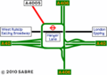
Hanger Lane Gyratory as it is today.

Links
- The Londonist: How London's Road Junctions Got Their Names 28.08.2014 (archive.org)
- Hanger Lane Tube station details
_David_Hawgood_-_Geograph_-_2573433.jpg)
_David_Hawgood_-_Geograph_-_2573444.jpg)
_David_Hawgood_-_Geograph_-_2573467.jpg)
