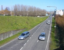
West Approach Road
| West Approach Road | |||
| Location Map ( geo) | |||
 | |||
| The spur split at Dalry | |||
| |||
| From: | Murrayfield (NT226726) | ||
| To: | Edinburgh West End (NT246734) | ||
| Distance: | 1.5 miles (2.4 km) | ||
| Meets: | A700 | ||
| Primary Destinations | |||
| Highway Authorities | |||
| Traditional Counties | |||
The West Approach Road (sometimes Western Approach Road) is a comparatively fast link into Edinburgh city centre from the west. It's partially recycled and reutilised railway route, partially new build through redeveloped ground, and part of a much bigger plan that would have made it all the way out through unused ground to the M8. Clearly it'll never reach that goal nowadays; although it was formerly free from pedestrians almost its entire length and mostly surrounded by industrial sites, the eastern section has now been repurposed to provide access to the newly redeveloped neighbourhood of Fountainbridge.
Route
It starts outside Murrayfield Stadium on Westfield Road, parallel to and sandwiched between but not particularly well linked to the A8 and A71. There's a trickly little T-junction here with Roseburn Street for the stadium entrance that poses some problems. Firstly, the road climbs so steeply it's difficult for traffic coming off the Approach Road to see traffic turning out of Roseburn Street and vice versa - this caused traffic lights to be installed, left covered for almost 18 months, finally activated, and then turned off again as no-one at Edinburgh City Council can decide which the safest option is. Secondly, two of the three roads at this junction are restricted: the Western Approach Road has some fierce restrictions, banning all vehicles (save for buses) over 1.5 tonnes - presumably, some estate cars and people-carriers are technically prohibited from it. All banned traffic presumably has to turn left into Roseburn Street - where it immediately comes face to face with a 12'9" railway bridge which is unsurprisingly prone to being struck.
Anyway, the road itself climbs sharply as described to get over the South Suburban railway line (freight only nowadays). The reason it goes over and not under that railway is that pretty much the entire road is an old hijacked railway alignment, part of the Caledonian Railway line into Princes Street Station (now the Caledonian Hotel at the West End). The line was required to bridge two other railways without junction, and also the Dalry Road (A70). After that there's a sharp right then left that presumably the railway line was never subjected to - a playpark has been constructed in the way.
A sliproad enters from the right after the double-bend, this is the only grade-separated junction on the route, with Dundee Street, complete with sharp gradient once more. There's a bus stop just after the merge despite pedestrians being banned from the road; a little pedestrian island and shelter is provided surrounded by verbose "No Pedestrians On West Approach Road" warnings. Pedestrians pass beneath the road here on the Telfer Underpass (although there have been threats that this may be closed). The road itself continues, now dualled and ruler straight, between swimming baths and the Fountain Park leisure complex (complete with westbound-only car park access) up to a recently-installed pedestrian crossing. Shortly beforehand the central reservation disappeared and the limit dropped from 40 to 30. Much of the surrounding land was formerly the breweries of Fountainbridge, but is now redeveloped as housing with an increasing number of frontages onto the road.
The last part has the appearance of an ordinary suburban road. It's no longer on the old railway line here, instead threading through some much younger buildings in the heart of a recently-developed financial services district. There are two more traffic light controlled junctions before the end of the road butts on to the A700 Lothian Road, barely a stone's throw from the West End.
History
The 2.27 mile road westwards from Lothian Road to Westfield Road with a spur to Dundee Street was due to open on 15 December 1974 (per The Scotsman of 13 December 1974). Cost £550,000. It was noted as a potential Principal Road in the 1974 Scottish Development Department Report.
