Star.pngStar.pngStar grey.pngStar grey.pngStar grey.png

Llys y Gwynt Interchange

From Roader's Digest: The SABRE Wiki
Jump to navigation Jump to search
Llys y Gwynt Interchange
Cyfnewidfa Llys y Gwynt
Location Map ( geo)
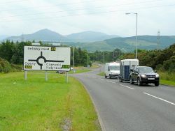
A55-A5122 junction - Geograph - 1397966.jpg
Looking south on the former A5122.
Cameraicon.png View gallery (1)
Location
Coed Hywel
County
Caernarfonshire
Highway Authority
Welsh Government
Junction Type
Roundabout Interchange
Roads Joined
A5, A55

Llys y Gwynt Interchange or Llandegai Interchange is Junction 11 of the A55.

Routes

Route To Notes

A5

Betws-y-coed, Llanberis (A4244), Gwasanaethau / Services, Bethesda 2

A55

Caergybi / Holyhead, Caernarfon (A487), Ysbyty Gwynedd / Gwynedd Hospital previously A5

A55

Conwy

A5

Bangor, Llandygai 1 previously A5122


Llys y Gwynt Interchange
Services
Related Pictures
View gallery (1)
A55-A5122 junction - Geograph - 1397966.jpg
Other nearby junctions
Bangor (Caernarfonshire)
Junctions on the A55
Kingsland • 2 Ty Mawr • 3 Caergeiliog • 4 Dalar Hir • 5 Treban • 6 Nant Turnpike • 7 Cefn Du • 7A Glan Menai • 8 Ael y Bowl • 8A Carreg Bran • 9 Treborth • 10 Caernarfon Road • 11 Llys y Gwynt • 12 Tal y Bont • 13 Abergwyngregyn • 14 Madryn • 15 Llanfairfechan • 15A Penmaenmawr • 16 Puffin  • 16A Dwygyfylchi • 17 Conwy Morfa • 18 Llandudno Junction • 19 Glan Conwy • 20 Conway Road • 21 Colwyn Bay • 22 Old Colwyn • 23 Llanddulas • 23A Pensarn  • 24 Faenol • 24A St Georges • 25 Bodelwyddan • 26 St Asaph Business Park  • 27 Talardy • 27A Pont Dafydd • 28 Waen • 29 Pant-y-Dulath • 30 Travellers Inn • 31 Caerwys (Crossways)  • 32 Dolphin • 32A Billy Jean's • 33 Northop • 33A Brookside • 33B Alltami • 34 Ewloe • 35 Dobshill • 36 Warren • 37 Broughton Junction • 38 Wrexham Road • 39 Boughton Heath • 40 Vicars Cross • 12(M53) Hoole Island
Junctions on the A5
London - CrickMarble Arch • Marylebone Flyover • Staples Corner • Canons Corner • Brockley • Elstree Crossroads • Park Street • King Harry • Peahen Crossroads • Friars Wash • Dunstable Crossroads • Chalk Hill Rdbt • M1 Junction 11A • Thorn Rdbt • Hockliffe Crossroads • Sheeps Lane Rdbt • Little Brickhill • Caldecotte • Redmoor • Portway • Abbey Hill • Old Stratford Rdbt • Tove Rdbt • Weedon Crossroads • Watford Crossroads • Kilsby • Halfway House Rdbt • DIRFT Rugby North Rdbt
Crick - TamworthCrick • DIRFT Rugby East Rdbt • DIRFT Rugby North Rdbt • Gibbet Rdbt • Cross in Hand • High Cross • Smockington Hollow • Stretton Baskerville • Sketchley Rdbt • Dodwells Rdbt • Longshoot • Higham Rdbt • Red Gate • Mancetter Rdbt • Holly Lane Rdbt • Grendon Rdbt • Dordon Rdbt • M42 Junction 10
Tamworth-TelfordM42 Junction 10 • Centurion • Glascote • Ventura Park • Mile Oak • Weeford • Wall Island • Muckley Corner • Rising Sun • The Turf • Churchbridge • Wynn's Corner • Longford Island • Gailey Interchange • Gailey Island • Pickmere Roundabout • Limekiln Bank Rdbt • Priorslee Rdbt • Priorslee Interchange • Hollinswood
Telford-OswestryHollinswood • Forge • Cluddley • Preston Island • Emstrey Island • Bayston Hill Rdbt • Edgebold Rdbt • Woodcote Rdbt • Churncote Rdbt • Felton Butler Rdbt • Wolfshead Rdbt • Queens Head Junction
Oswestry-HolyheadQueens Head Junction • Mile End Rdbt • Whittington Rdbt • Five Crosses • Gledrid Rdbt • Halton Rdbt • Whitehurst Rdbt • Llys y Gwynt • Antelope Rdbt • Anglesey Arms • Carreg Bran • Glan Menai • Nant Turnpike • Dalar Hir • Caergeiliog

SABRE - The Society for All British and Irish Road Enthusiasts
Discuss - Digest - Discover - Help