Star.pngStar.pngStar.pngStar grey.pngStar grey.png

Weeford Interchange

From Roader's Digest: The SABRE Wiki
Jump to navigation Jump to search
Weeford Interchange
Location Map ( geo)
A5 Weeford bypass western roundabout - Coppermine - 3672.jpg
Cameraicon.png View gallery (6)
Location
Weeford
County
Staffordshire
Highway Authority
National Highways
Junction Type
Grade separated roundabout + Trumpet
Roads Joined
A38, A5, M6 Toll, C36
Junctions related to the M6 Toll

Weeford Interchange is a junction on the A38 in Staffordshire connecting with the A5 and M6 Toll. It is junction T4 of the M6 Toll.

It was previously known as Weeford Tollgate Cross-roads, then Weeford Roundabout.

History

The Crossroads

The junction was originally a crossroads. A number of serious and fatal accidents occurred at the junction during the 1930's and a campaign by the Lichfield Mercury prompted the local MP to bring it to the attention of the Minister of Transport. His reply on 10 November 1938 in Hansard is "My attention has been called to accidents which have occurred at the junction of A.5 and A.446 near Weeford. Authority was given on 1st November for the erection of "Halt" signs at this point and I am informed that the Staffordshire County Council are giving very early consideration to the question of constructing a roundabout there". The illuminated "Halt" signs were erected on Watling Street (A5) on 10 November 1938.

Accidents continued which may have been because some were still assuming that the A5 had priority. There was a report in October 1947 that the junction was still a crossroads with a Halt sign.

The first roundabout

A small roundabout is shown on the 1951 OS 2 1/2 inch map and a report in the Lichfield Mercury on 3 October 1952 mentions the roundabout.

The second roundabout

This was part of the first stage of the dualling of the then A446 from Lichfield to Bassett's Pole. Galliford and Sons Ltd. won the contract for the 2.5 mile section south from the junction to Weeford Park (Canwell) which was due to be completed by Spring 1969. Roadworks reports continued until November 1968 and the larger roundabout is shown on the January 1969 OS One inch map.

The 1969 map still shows the cottages in the middle of the large roundabout since the Ministry of Transport did not purchase the cottages until after the roundabout's completion. The householders, having suffered the construction work and traffic around them, then moved out and the cottages were demolished. The cottages were built in the 1920s and were believed to be on the site of the former tollgate.

The dual carriageway northwards is shown on the February 1973 OS Quarter inch map.

M6 Toll Interchange

The M6 Toll opened on 9 December 2003.

Maps

A small roundabout is showing by 1951
The new roundabout shown in 1969 with southwards dualling.
Northwards dualling shown in 1973.
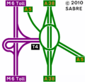
Routes

Route To Notes

M6 Toll

The NORTH WEST (M6 North), Cannock

M6 Toll

The SOUTH (M6, M42), Coventry, Birmingham, Sutton Coldfield

A5

Brownhills, (M6 North)

A5

(M42 (North), Tamworth

A38

Burton, Lichfield

A38

Birmingham

C36

Hints, Weeford Watling Street, former A5

M600

The NORTH WEST (M6 North), Cannock administrative number for M6 Toll

M600

The SOUTH (M6, M42), Coventry, Birmingham, Sutton Coldfield administrative number for M6 Toll

A446(M)

The NORTH WEST (M6 North), Cannock provisional number for M6 Toll

A446(M)

The SOUTH (M6, M42), Coventry, Birmingham, Sutton Coldfield provisional number for M6 Toll


Weeford Interchange
Related Pictures
View gallery (6)
A38 Weeford GSJ facing north - Coppermine - 2950.jpgA38 Weeford GSJ looking south - Coppermine - 2949.jpgA38 Weeford GSJ - Coppermine - 2952.jpgBrumQ16 - Coppermine - 1752.jpgA5 Weeford bypass western roundabout - Coppermine - 3672.jpg
Junctions on the A5
London - CrickMarble Arch • Marylebone Flyover • Staples Corner • Canons Corner • Brockley • Elstree Crossroads • Park Street • King Harry • Peahen Crossroads • Friars Wash • Dunstable Crossroads • Chalk Hill Rdbt • M1 Junction 11A • Thorn Rdbt • Hockliffe Crossroads • Sheeps Lane Rdbt • Little Brickhill • Caldecotte • Redmoor • Portway • Abbey Hill • Old Stratford Rdbt • Tove Rdbt • Weedon Crossroads • Watford Crossroads • Kilsby • Halfway House Rdbt • DIRFT Rugby North Rdbt
Crick - TamworthCrick • DIRFT Rugby East Rdbt • DIRFT Rugby North Rdbt • Gibbet Rdbt • Cross in Hand • High Cross • Smockington Hollow • Stretton Baskerville • Sketchley Rdbt • Dodwells Rdbt • Longshoot • Higham Rdbt • Red Gate • Mancetter Rdbt • Holly Lane Rdbt • Grendon Rdbt • Dordon Rdbt • M42 Junction 10
Tamworth-TelfordM42 Junction 10 • Centurion • Glascote • Ventura Park • Mile Oak • Weeford • Wall Island • Muckley Corner • Rising Sun • The Turf • Churchbridge • Wynn's Corner • Longford Island • Gailey Interchange • Gailey Island • Pickmere Roundabout • Limekiln Bank Rdbt • Priorslee Rdbt • Priorslee Interchange • Hollinswood
Telford-OswestryHollinswood • Forge • Cluddley • Preston Island • Emstrey Island • Bayston Hill Rdbt • Edgebold Rdbt • Woodcote Rdbt • Churncote Rdbt • Felton Butler Rdbt • Wolfshead Rdbt • Queens Head Junction
Oswestry-HolyheadQueens Head Junction • Mile End Rdbt • Whittington Rdbt • Five Crosses • Gledrid Rdbt • Halton Rdbt • Whitehurst Rdbt • Llys y Gwynt • Antelope Rdbt • Anglesey Arms • Carreg Bran • Glan Menai • Nant Turnpike • Dalar Hir • Caergeiliog
Junctions on the A38
Bodmin - ExeterCallywith • Toll Gate House • Carminow Cross • Turfdown Roundabout • Twelvewoods Roundabout • Looe Mills • Moorswater • Island Shop • Lean Quarry • Menheniot • Trerulefoot Roundabout • Notter Bridge • Stoketon Cross • Latchbrook • Carkeel Roundabout • Saltash Town • St Budeaux • Weston Mill • Manadon • Forder Valley • Marsh Mills • Deep Lane • Voss Farm • Smithaleigh • Lee Mill • Westover • Wrangaton Cross • Woodpecker • Marley Head • Drybridge • Lower Dean • Dart Bridge • Peartree • Linhay Hill • Goodstone Cross • Drumbridges • Clay Lane • Chudleigh Station • Harcombe • Haldon • Splatford Split • Kennford • Wobbly Wheel • Pearce's Hill • Cullumpton
Tiverton - BristolTiverton Parkway • Waterloo Cross • Maiden Down • Perry Elm Roundabout • Chelston Roundabout • Chelston • Creech Castle • Walford Cross • Huntworth • Cross Rifles Roundabout • Dunball Roundabout • Edithmead • Cornhill • East Brent Roundabout • Cross • Churchill Gate Crossroads • Barrow Tanks • Lime Kiln Roundabout • Bedminster Bridge
Bristol - BirminghamSt James Barton • Filton Roundabout • Aztec West • Almondsbury Roundabout • Cross Keys Roundabout • Waterwells Roundabout • Wall's Roundabout • Coombe Hill • Gupshill Roundabout • Twyning • Rashwood • Slideshow Island • Harvester Island • Lydiate Ash • The Black Horse Junction • The Isaac Tongue Junction • Belgrave Interchange • Holloway Circus  • Paradise Circus  • St Chads Circus  • Lancaster Circus  • Dartmouth Circus • Park Circus
Birmingham - MansfieldGravelly Hill • Salford Circus • Birches Green • The Norton Crossroads • Tyburn House Island • Minworth Island • Langely Mill • Bassetts Pole • Weeford • Swinfen • Streethay • Hillards Cross • Barton Turn • Branston Junction • Clay Mills • Toyota Island • Findern • Kingsway Roundabout • Markeaton Island • Palm Court Island • Little Eaton Roundabout • Coxbench • Hartshay • Alfreton • Pinxton


SABRE - The Society for All British and Irish Road Enthusiasts
Discuss - Digest - Discover - Help