Churchbridge
| Churchbridge | |||
| Location Map ( geo) | |||
 | |||
| |||
| Location | |||
| Cannock | |||
| County | |||
| Staffordshire | |||
| Highway Authority | |||
| National Highways • Staffordshire • Midland Expressway | |||
| Junction Type | |||
| Magic Gyratory variant | |||
| Roads Joined | |||
| M6 Toll, A5, A34, A460 | |||
| Junctions related to the A460 | |||
Elephant and Castle (Wolverhampton) • Queen's Square (Cannock) • Scotlands Island • Princes Square • Laney Green Interchange • Wedges Mills Interchange • Featherstone Interchange • Longford Island • Brereton Roundabout • Cat Roundabout • Globe Island • Hayes Way Island • Mill Green Island • Hawks Green Island | |||
| Junctions related to the M6 Toll | |||
Churchbridge is junction T7 of the M6 Toll.
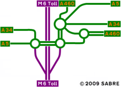
Churchbridge is a Magic Gyratory variant to the southeast of the former mining town of Cannock, Staffordshire. The present junction was built as part of the M6 Toll construction, and replaced a string of three roundabouts.
It is a combination of a three-roundabout Magic Gyratory, and a dumbbell, with one of the roundabouts being part of both junctions.
It is located at the junction of four major routes:
- M6 Toll junction T7
- A5 between Brownhills and M6 junction 12
- A34 between Walsall and Stafford
- A460 between Wolverhampton and Rugeley
It is slightly unusual in that the junction is managed by three different bodies:
- National Highways manage the through route along A5 and so manage the three roundabouts directly along the A5 route, as well as the links between
- Staffordshire Council manage the northernmost roundabout, and the links from this roundabout to the remainder of the junction
- Midland Expressway manage the slip roads to and from M6 Toll
History
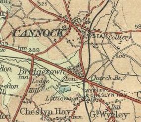
The junction was originally a relatively simple staggered junction between A5 and A34, though extra complexity was added by the presence of a railway line and a canal within the junction area. The canal and the associated Churchbridge Locks was filled in during the 1960s, though the railway line is still in use today.
During the 1980s, the Cannock Eastern Bypass was constructed, and the A460 was brought into the junction layout to the north, with the former route through Cannock Town Centre becoming A4601, and a multiplex with A5 through Bridgetown created. At this point, the junction was redesigned with three small roundabouts:
- the eastern end of the junction serving A5 towards Brownhills and A34 towards Walsall
- central serving A5 to the west and access to the other roundabouts
- northern serving A34 towards Cannock and A460 towards Rugeley
This junction layout was known locally as "The Silly Isles", as the majority of traffic needed to pass through the central roundabout in the system, causing long traffic delays.
The layout was then altered to the present form in 2002-3, with the addition of M6 Toll and the A460 for traffic towards Wolverhampton. Whilst much improved over its previous form, there are still large tailbacks at busy times, but as there is no single dominant flow of traffic, any further improvements are unlikely to be easily attained.
In 2015 traffic signals were added to three of the roundabouts, some of the approaches were widened and the northernmost M6 Toll roundabout was converted into a teardrop; whilst in late 2018 work started on widening the links between the northern roundabout and the remainder of the junction to dual carriageway.
Original BNRR proposals
Before the Birmingham Northern Relief Road was planned as a toll road the junction was to be a roundabout interchange with slip roads in both directions. The railway prevents one large centrally located roundabout with all the main roads feeding directly onto it so there are two smaller roundabouts in the same locations as what currently exists. The presence of the west facing slips means there is no need for the A460 running parallel to the motorway. It also means there is no space for a link between the main roundabout and the bottom left roundabout. With only three arms and filter lanes for two of the left turns this roundabout could well cope better with the demands that currently overwhelm it.
When it was decided to promote the scheme as a toll road the initial proposal from Midland Expressway retained the existing proposed junction and added toll booths to the west facing slips. The design soon changed and the westbound slips were omitted and replaced with the A460 running parallel to the M6 Toll towards M6 J11. Large roundabout interchanges tend to be unfavourable with toll roads due to the extra toll booths required and in the case of Churchbridge the predicted level of traffic using the west facing slips was thought to be low.
Routes
| Route | To | Notes |
| The SOUTH, Burntwood | ||
| Telford | ||
| Brownhills | ||
| Cannock town centre | ||
| Walsall | ||
| Wolverhampton | ||
| Rugeley | ||
| Walsall | now part of A34 | |
| Cannock | now part of A34 | |
| The SOUTH, Burntwood | administrative number for M6 Toll | |
| The SOUTH, Burntwood | provisional number for M6 Toll |


