A825 (Gourock)
| A825 | ||||
 | ||||
| Tarbet Street | ||||
| From: | Gourock (NS248772) | |||
| To: | Gourock Bay (NS243776) | |||
| Distance: | 0.4 miles (0.6 km) | |||
| Met (1965): | A8, Pier | |||
| Now part of: | A771 | |||
| Traditional Counties | ||||
| Route outline (key) | ||||
| ||||
For the other former A825 in Crieff, see A825 (Crieff).

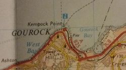
Although not shown on the 1976 sheet, the 1978 revision of the OS Landranger 1:50000 Sheet 63 of the Firth of Clyde shows the A825 as the Gourock pier road, Tarbet Street, which is now the A771. Curious. This means that the A825 was briefly the road to Gourock Bay. Most of the road didn't even exist in 1960, and was built subsequently, presumably when the pier was rebuilt. Like the road today, it is a very short road less than a mile long, along Tarbet Street.
The main reason this road was subsequently renumbered is because of the re-routing of the A78 though the Spango Valley in 1985. When this happened, the A78 killed off the A742, the old A78 though Gourock became the A770 and the end of the A8 moved to Central Greenock. It is the moving of the A8 that caused the road to be renumbered A771 as the zone boundary moved eastwards along the Clyde.
For a proper description of this road, read the A771 account, which is still the current number of the road.
| A825 (Gourock) | ||||
| ||||
| ||||
| ||||
|
This page includes a scan of a non-free copyrighted map, and the copyright for it is most likely held by the company or person that produced the map. It is believed that the use of a limited number of web-resolution scans qualifies as fair use under United States copyright law, where this web page is hosted, as such display does not significantly impede the right of the copyright holder to sell the copyrighted material, is not being used to generate profit in this context, and presents information that cannot be exhibited otherwise.
If the copyright holder considers this is an infringement of their rights, please contact the Site Management Team to discuss further steps.


