A864
| A864 | ||||
| Location Map ( geo) | ||||
| ||||
| From: | Lonmore (NG275458) | |||
| To: | Horneval (NG274484) | |||
| Distance: | 1.6 miles (2.6 km) | |||
| Met: | A863, A850 | |||
| Now part of: | C1245 | |||
| Traditional Counties | ||||
| Route outline (key) | ||||
| ||||
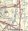
The A864 was a short single-track route linking the A850 with the A863 to the East of Dunvegan on Skye. Towards the end, the road also had a 250 m long spur at its southern terminus, forming a triangular junction with the A863. The spur is a result of the A863 being realigned to cut off a sharp corner at the old junction, and so the A864 gained both arms of the former A863, to south and west.
The road was unclassified in 1922, becoming the A864 perhaps as early as 1923 or 24, presumably at the same time as the A863 was upgraded from being the B883. However, along with several other short, minor Class I roads on Skye it was downgraded in the mid 1980s and is now classified as the C1245. Despite this, there was, and perhaps still is at least one sign still showing the A864 number on the road (the sign was in poor condition in late 2021). Curiously, at the northern end, it is signed as the A863, without brackets, but nowhere is it shown as an A road on maps. Highland Council now list it as the C1245.


