Milestones
| Milestones | |
 | |
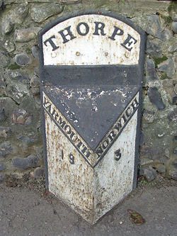
| An old metal mile'stone' at Thorpe, on the outskirts of Norwich | |
| Pictures related to Milestones View gallery (257) | |
Milestones originally date back as far as Roman times, however the ones we see at the roadside today became common in 1767, when they became compulsory on all Turnpike Roads. These were erected and maintained by the road's owner. However, when Turnpikes were handed over to the county and local councils in 1888, so were the milestones. Many were replaced with cast iron 'stones', of which many still exist today.
Purpose
In their time, Milestones served a real purpose. At the time signposts were a very rare thing, if they existed at all. Therefore milestones served a dual purpose of confirming that the traveller was on the right road, and the distance to the next town. The lack of arrows denoting directions was not such a big issue, as travellers had generally either come from one of the towns indicated, or were local enough to know where they were anyway.
They were also used by mail and stage coaches to check time, for instance the journey from Bristol to Taunton might take 5 hours, and the drivers would know timings between milestones to ensure that they kept to schedule.
Distances
Despite what you may think, Milestones do not necessarily appear at 1 mile intervals along roads. Even distances marked are not necessarily whole numbers of miles away, half miles appear occasionally, and less frequently ¼ and ¾ are also used. The reason behind this is that towns are very rarely whole miles apart. When Milestones were first placed on our roadsides, they were often set to mark the miles between the extremities of the route. For instance, on the A5 Holyhead road Holyhead is marked from at least 102 miles away, while intermediate towns may be marked with halves or quarters. In fact the surviving stones are often old enough to mark furlongs!
Even over long distances, it was rarely a whole number of miles from one town to another. The A82 across Rannoch Moor bears milestones for Kinlochleven and Tyndrum. However, in the 20 or so miles between Glencoe and Bridge of Orchy the milestones seem to gain an extra 0.2 miles (according to a comparison with a very small number of odometers). This could be down to a number of things. Firstly the twists and turns of the road, combined with some slight realignments may have adjusted the distance. Secondly, it may have been a slight stretch added to provide for whole miles. Thirdly, of course, the cars might not be very accurate!
There are other reasons why the distances between milestones may no longer be whole miles. For instance the A38 around East Brent and Rooksbridge seems to have lost half a mile when it was re-aligned in the 1930s, and yet the milestones were never adjusted.
Designs
There are a vast range of designs of Milestones to be found on the roadsides around the country. The earliest were often no more than roadside stones painted or inscribed with the distances. Later, stones were mass-produced by quarries or stonemasons, just like grave stones, such was the demand in the period around 1767. By the Victorian era, Iron was often supplanting stone, either as a cast plaque mounted on a stone, or in any range of designs as a stand alone post. They were normally produced in a triangular format, so facing traffic travelling in either direction. A common design in the West Highlands can be seen to the right, while the image at the top could be seen elsewhere in the country.
By the 1930s Concrete was more commonly used on those roads where they were still being placed. The problem with concrete is that they are much harder to inscribe than stone, so iron plaques or paint were used to denote the distances. With time those that were once painted have often lost the paint, so leaving bare concrete pillars on the verges. While this can also be true for true milestones, the concrete posts seem to have suffered much more.
The Present Era
In the modern road era, the placing of milestones has been superseded by the placement of specific road features for particular purposes. Specifically:
- Route Confirmation Signs generally include distances to onward destinations
- Driver Location Signs, which are used by National Highways on the trunk road network provide regular distance location information, to assist road users in the event that relaying their location is required.
- Smaller distance marker posts are used at regular intervals for road maintenance and cataloguing purposes
Additionally, in tandem with distance markers, Fingerposts and more recently Flag Signs have been used at junctions to indicate direction and distance to the signed destination.
Links
- The Milestone Society - a society with the aims to identify, record, research, conserve and interpret for public benefit the milestones and other waymarkers of the British Isles


