E Roads
| E Roads | |
 | |
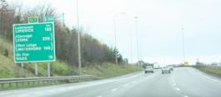
| An E-Road signed in the Republic of Ireland | |
| Pictures related to E Roads View gallery (1) | |
For the proposed road link between Great Britain and France, see Euroroute.
The International E-road network is a system of roads across Europe and the former Soviet Union. It is co-ordinated by the Economic Commission for Europe, a United Nations agency. The original agreement was drawn up in 1950 and has been modified several times since then. The agreement specifies:
· The numbering convention
· The routes to be used
· The quality of roads to be used
The numbering convention
After a major re-organisation of the road numbers in 1975 (implemented 1983), the basis for the road numbers are that east-west roads should be even-numbered and north-south roads should be odd-numbered. Apart from a few north-south roads that are mainly in Russia and some short “branch, link or connecting roads” all the E-roads have two-digit numbers.
Reference roads
The agreement specifies a number of East-West “reference roads” with numbers E10, E20, E30 etc up to E90 with the E10 being the most northerly of the roads and the E90 the most southerly of the roads. Similarly, the agreement specified a number of North-South “reference roads” with numbers E05, E15, E25 etc up to E105 with the E05 being the most westerly of the roads and the E105 the most easterly.
Intermediate roads
Intermediate roads were then assigned so that as far as possible the road numbers formed a grid. A few exceptions were made in the case of certain Scandinavian roads as they had incorporated the earlier E-road numbering system into their national roads numbering system.
Branch, link, and connecting roads
Finally, the agreement makes provision for “Branch, link, and connecting roads” – short stretches of road that are of strategic importance in the European network. These have three digits.
The original system
The original system numbered routes (which took any direction they wanted - even loops) sequentially in sets. 1-30 were major corridors, 31-99 were intermediate, 100+ were branches and connectors.
The routes to be used
The agreement specifies the routes to be used only in terms of city names, leaving it up to the country concerned to identify the best roads to be used for the route. The agreement does however lay down rule about the type of road that should be used.
Road Standards
The following design standards should be applied to E-roads unless there are exceptional circumstances (such as mountain passes etc):
Units listed in metric first as per standards, Imperial conversions to nearest appropriate unit.
· The roads should be homogeneous and be designed for at least 100 km/h (62 mph).
· Gradients should not exceed 8% on roads designed for 60 km/h (37 mph), decreasing to 4% on roads designed for 120 km/h (74 mph) traffic.
· The radius of curved sections of road should not exceed 120 m (393 feet) on roads designed for 60 km/h (37 mph) rising to 1000 m (3280 feet) on roads designed for 140 km/h (87 mph).
· "Stopping distance visibility" should be at least 70 m (230 feet) on roads designed for 60 km/h (37 mph), rising to 300 m (984 feet) on roads designed for 140 km/h (87 mph).
· Lane width should be at least 3.5 m (11 feet 6 inches) on straight sections of road.
· The hard shoulder should be at least 2.5 m (8 feet 2 inches) on ordinary roads and 3.25 m (10 feet 8 inches) on motorways.
· Central reservations should be at least 3 m (9 feet 10 inches) unless there is a barrier between the two carriageways.
· Overhead clearance should be not less than 4.5 m (14 feet 9 inches)
E-roads in the British Isles
In the Republic of Ireland E-road numbers are indicated on route confirmation signs. In the United Kingdom they are not signed at all.
Table notes - '...' means a sea route (may not have ferry). Routes that are being upgraded to motorway and/or have lots of motorway sections (eg. Irish N roads and the A1 in England) are shown as N7/M7 or A1/A1(M) to save space.
Other notes: routes are best-guesses and may not be fully accurate – especially in the UK, where E-roads are unsigned.
Only sections within the British Isles (UK and RoI) are shown. The E01, E05, E15, E16, E18, E20, E22 and E30 continue on the European mainland.
For a history of E-roads in the British Isles, see E Roads/History
E-roads elsewhere
see main articles E-roads/A-class/odd, E-roads/A-class/even, E-roads/B-class
Further Information
For more details, see
- roadsUK
- MartMix
- United Nations Ecomomic Commission for Europe: European Agreement on Main International Traffic Arteries.
| Route | From | To | Length |
|
|---|