Dingwall
| Dingwall Inbhir Pheofharain | |||
| Location Map ( geo) | |||
 | |||
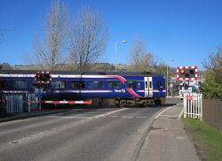
| Level Crossing in Dingwall | |||
| |||
| County | |||
| Ross-shire | |||
| Highway Authority | |||
| Highland | |||
| Transport Scotland Roads | |||
| A835 | |||
| Places related to the A862 | |||
| Places related to the A835 | |||
Dingwall is one of the larger towns in the Highland Council area, but it is by no means big. Formerly the county town of Ross-shire, it lay across the A9 until the town was effectively bypassed by the Cromarty Bridge and Kessock Bridge. Between them, they reduced the towns importance by making the Highland Capital, Inverness a lot easier to reach for the surrounding towns and villages.
For a few years in the late 1970s and early 1980s, the roads in the town seem to have moved about quite a bit, no doubt related to the imminent re-routing of the A9, and trying to keep traffic flowing in the interim. The historic route of the A9 had been to enter the town from the south along Station Road, turn left along the High Street, then right onto Tulloch Street to cross the river. The 1946 OS 10 mile map shows an early attempt to alleviate traffic, with the B859 forming a loop to the south of the town centre. However at present the precise route follows is uncertain.
Move forward to 1976 and the OS Landranger sheet shows that in addition to the historic route, another A road runs slightly to the west, although no numbers are given for any of the routes within the town at this scale. The 'new' route follows the eastern end of Greenhill Street, then turns north up Hill Street. A second loop then follows the current route of the A862 along Newton Road. The western part of Greenhill Street was subsequently built, and the main road diverted out of the town centre. However, at present it is not clear if this was completed before or after the A9 was re-routed.
A few years later, with the new roads slowly opening in advance of the completion of the Kessock Bridge, what is now the A835 from Maryburgh to Tore Roundabout was briefly numbered as an extension of the A834, before the Conon Bridge bypass section was completed.
Dingwall is still a busy town, however, with the the tourists passing through on their way to nearby Strathpeffer, or just following the Moray Firth Tourist Route. The town is also where the Skye Railway Line to Kyle of Lochalsh branches off the far north line, and so there are a number of level crossings, including on the two main roads the A862 (former A9) and A834. To the south of Dingwall, the A835 passes through the Maryburgh Roundabout on its way from the A9 at Tore Roundabout to the ferry port of Ullapool. The A862 between Dingwall and the A835 was heavily rebuilt a few years ago, parallel to the old road which is now partly retained as a cycle route.
Routes
| Route | To | Notes |
| Inverness (A9) | ||
| Ullapool | ||
| Strath Pheofhair / Strathpeffer, Ullapool (A835) | was briefly A835 (1963 10 mile Road Map) | |
| Baile Dhubhthaich / Tain, Inbhir Theòrsa / Thurso (A9) | Moray Firth Tourist Route and NC500. Was A9, originally A88. | |
| Baile Mairi / Maryburgh, Inbhir Nis / Inverness (A835) | Moray Firth Tourist Route and NC500. Was A9, originally A88. | |
| Tore Roundabout | brief extension in advance of the completion of the Conon Bridge bypass and the extension of the A835 through to Tore. | |
| short link to south of the town that briefly existed |


