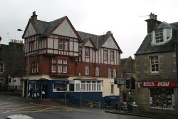
Callander
| Callander | |||
| Location Map ( geo) | |||
 | |||
| |||
| County | |||
| Perthshire | |||
| Highway Authority | |||
| Stirling | |||
| Transport Scotland Roads | |||
| A84 | |||
| Places related to the A84 | |||
| Places related to the A81 | |||
The small town of Callander lies astride the A84 on the banks of the River Teith, an important tributary of the Forth. The town is a genteel place popular with the passing coach tours as it is the largest town in the Trossachs part of the national park. A visitor centre occupies an old church in the square, with shops, cafes and hotels stretching along the main street in either direction, not just serving the tourists but also the vast rural hinterland to the west. The town is also within commuting distance of Stirling, and a popular retirement place for some.
The main road through the town is, as noted above, the A84. This runs east to west, from Stirling and Doune to Lochearnhead, where it joins the A85 to Crianlarich and the West Highlands. The A81 terminates at the west end of the town centre, having taken a meandering route north from Glasgow which is little used as a through route, despite the important sounding number it carries.
A mile or so out of town, the A81 meets the B822, with the B8032 forking off the B822 a short distance further on. The B822 heads south, itself taking a meandering route through the Trossachs, over the Campsie Fells and down to the northern fringe of Glasgow, whilst the B8032 follows the south bank of the River Teith back to Doune and the A84. Closer in to the town centre, a mini roundabout on the A81 marks the junction with the Invertrossachs Road, originally the B828, then the A892, it is now unclassified. An even odder classified road also used to exist in the town centre, the B8061 which followed a dead-end side street for about 100 yards.
Junction
Despite the A84 being one of the main access routes from the south to the Highlands, it still runs along the towns High Street, lined with shops and parked cars. Towards the western end of this long main street is a traffic signal controlled junction, where the A81 turns to the south, across Callander Bridge and takes a rather indirect route down to Glasgow.
The junction is a crossroads, with Cross Street (the former B8061), opposite the A81, being a minor side street. On the approach to the lights, parking on the A84 is cut back to provide two turning lanes at the stop lines. Despite the disparity in right turning traffic in each direction, in each case the left hand lane is for left and straight on, while the right hand lane is for right turning only. In practice, the double yellow lines are often flouted, whether by parked cars or delivery vehicles, and so the left lane is often only available for one or two cars, if at all.
From the A81 and Cross Street there is only one approach lane, but with little traffic from Cross Street this seems to be sufficient to maintain traffic flow. The whole junction area is also controlled by a yellow box to keep traffic flowing as much as possible.
Routes
| Route | To | Notes |
| Crianlarich (A85) | ||
| Stirling, Doune | Trossachs Trail | |
| Glasgow | A slow and circuitous route | |
| Aberfoyle, Loch Katrine, Trossachs | Trossachs Trail starts at Kilmahog Junction | |
| Thornhill, Kippen | ||
| Doune | ||
| Link between A81 and A821, formerly B828 | ||
| Cross Street - a dead end at the time |


