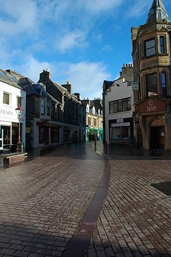
Wick
| Wick Inbhir Ùige | |||
| Location Map ( geo) | |||
 | |||
| Town Centre, Wick | |||
| |||
| County | |||
| Caithness | |||
| Highway Authority | |||
| Highland | |||
| Forward Destination on | |||
| A99, A882 | |||
| Next Primary Destinations | |||
| Inverness, Thurso | |||
| Places related to the A99 | |||
| Places related to the A882 | |||
Wick is a fishing port on the east coast of Caithness, just 20 or so miles south of John O'Groats. It was the county town of Caithness and still has the main office for this northern part of Highland Council. The town was largely developed by Thomas Telford, and the British Fisheries in the late 18th Century, and is now the second largest town in Caithness. Apart form the fishing industry, there are a number of other industrial areas in and around Wick, and the airport is the most northerly public one on the British Mainland, which offers flights to Aberdeen and Edinburgh. The flatter lands of Caithness (as opposed to the rest of the Highlands) enables some farming in the hinterland around Wick, but today tourism is important to the town, as it lies on the main route north to John o Groats.
Both the A9 and its predecessor the A88 were originally routed through the town, but the A9 has now been diverted to the west, taking the direct route to Thurso and the port of Scrabster for the ferry to Orkney. Therefore, since 1996 the A99 has served the town, being primary and trunk from the south, but non primary to the north as far as John o Groats. The A882 heads west to Thurso, as does the B874 which turns off the A99 at the airport, and the B876, which starts at a TOTSO on a little further from the town. In the town centre itself, the B9159 follows the river out to the harbour, and is the last survivor of a number of short classified roads that have existed in the past.
As seen in the table below, then, Wick has seen an unusually high number of short, and short-lived classified roads, mostly designed to serve the harbour area. The B874 originally served it, but was upgraded to be the A896, and then the A8002, although there is no apparent reason why the number was changed, and mapping evidence is inconclusive as to whether they followed the same route. At one time, a spur of the A882 also ran into the harbour area, whilst the A8002 also appears to have served the station across the A9 (as was), explaining why it carried a zone 8 number in place of the expected zone 9 number. The A9, which is now the A99, was also originally the A88, when the whole of the far north was in zone 8.
Routes
| Route | To | Notes |
| Inverness (A9) | ||
| Watten, Thurso (A9) | ||
| John o' Groats | ||
| Sibster, Gillock | ||
| Castletown | ||
| John o' Groats | now A99 | |
| Inverness | now A9 | |
| Thurso | now A99 and B876/A882, depending on when | |
| Inverness | now A99 | |
| John o' Groats | now A99 | |
| link to harbour in the early '30s | ||
| link to harbour post-1938 | ||
| link to harbour in the 1920s | ||
| John o' Groats | now A99 | |
| link to harbour, forming loop off A9 |
Links


