Thurso
| Thurso Inbhir Theòrsa | |||
| Location Map ( geo) | |||
 | |||
| Thurso Castle | |||
| |||
| County | |||
| Caithness | |||
| Highway Authority | |||
| Highland | |||
| Forward Destination on | |||
| A9 | |||
| Next Primary Destinations | |||
| Inverness • Wick | |||
| Other Nearby Primary Destinations | |||
| Ullapool | |||
| Places related to the A9 | |||
Stirling • Inverness • Perth • Falkirk • Edinburgh • Wick • Aviemore • Newtonmore • Pitlochry • Dingwall • Linlithgow • Tain • Alness • Dunblane • Muir of Ord • John o Groats • Helmsdale | |||
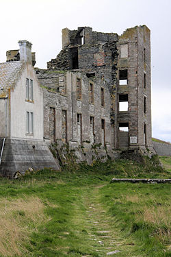
Thurso is the most northerly town of the British mainland, lying 20 miles to the west of John o' Groats. Nearby Scrabster is the port for the Northlink Ferries to Orkney, although the Pentland Ferry operates a shorter, quicker crossing from Gills Bay nearer John o' Groats. The town has a long history, having been a Norse port during the Norse rule of Caithness, but much of what we see today came from the rebuilding in the 19th century to a grid-iron street pattern. The town has expanded further, more recently, with housing for the workers at nearby Dounreay, and also the growth in tourism to the far north. Thurso also acts as an important service town for a vast, if sparsely populated, hinterland which loosely includes parts of the Orkney Isles.
These days, the main road through the town is the A9, arriving from the south and terminating at Scrabster port. For many years, this was the A882, the A9 running to John o Groats, but the roads were renumbered in the mid 1990s. This saw the A9 rerouted away from Wick and take over the route of the A895, and part of the A882. Crossing the A9 is the A836, which runs along the north coast from Tongue in the west to John o Groats in the east. The B874 heads south out of town, paralleling the A9 on the other side of the Thurso River. A mile or so out of town, the B870 forks off the B874 , but the two recross on the far side of the A9, after both taking meandering routes. To the east of Thurso, at Castletown, the B876 forks off the A836 and heads south east to Wick.
The only other classified road in Thurso is the B877. This is part pedestrianised along the High Street, as it runs out to the towns harbour, and is of little use to anyone as a result! However, as can be seen in the table below, there are a lot of other road numbers that have been associated with the town over the years. Most are from the very early years of road numbering and became defunct in the 1930s, but the A840 and A8001 both survived into the 1960s, each providing short links in and around the town centre.
Routes
| Route | To | Notes |
| Scrabster Ferry | ||
| Inverness, Wick (A882) | ||
| John o' Groats | ||
| Tongue, Durness | Scenic Route to Ullapool | |
| Calder | ||
| Halkirk | ||
| Wick | from Castletown | |
| Scrabster Ferry | now A9 | |
| Inverness, Wick | now either A836/B876 or A9/A882, depending on when | |
| Station, Halkirk (B874) | Station approach, now part of B874 | |
| John o' Groats | now A836 | |
| Scrabster Ferry | now A9 | |
| Inverness (A895), Wick | now A9 | |
| Short link at Sir Johns Square / Princess Street | ||
| Tongue | now A836 | |
| Georgemass Junction, Latheron | now A9 | |
| John o' Groats | now A836 |
Links


