Dublin Outer Orbital Route
| Dublin Outer Orbital Route | ||||||||||||||||
 | ||||||||||||||||
| From: | Sir John Rogerson's Quay (O172342) | |||||||||||||||
| To: | Spencer Dock (O171344) | |||||||||||||||
| Meets: | R101, R105, R108, R109, R110, R111, R114, R117, R118, R132, R137, R138, R147, R801, R802, R803, R805, R806, R810, R811, R812, R813, R815, R816, R839 | |||||||||||||||
| Highway Authorities | ||||||||||||||||
| Traditional Counties | ||||||||||||||||
| Route outline (key) | ||||||||||||||||
| ||||||||||||||||
The Dublin Outer Orbital Route is a Ring Road created out of existing streets within the city. It allows traffic to get across the city without needing to head into the congested central area.
The route broadly follows the two canals, which are considered to define the limits of the city centre.
29 of the junctions along this route have been given an identifying number. Since March 2020, these junction numbers have begun at Samuel Beckett Bridge with J51, and head clockwise to J80. Lower junction numbers are used by the Inner Orbital.
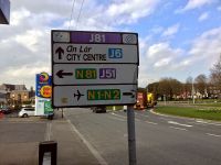
Road Signs

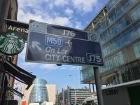
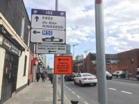
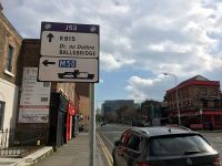
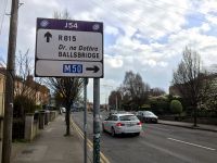
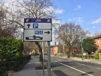
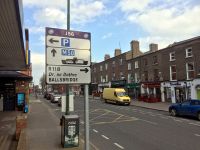
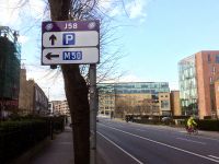
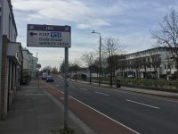
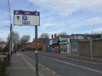
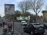
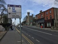
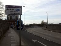
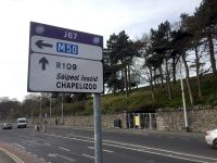
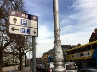
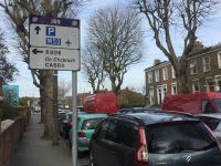
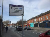
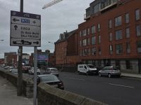
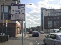
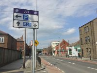
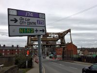
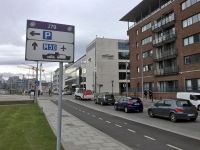
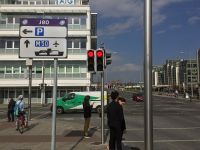
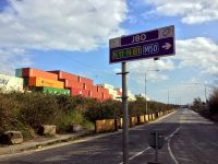
The Outer Orbital has always had a purple colour scheme. All signs have a purple heading with the junction number, the 'ring road' logo and (until 2020) the City Council logo.
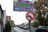
Signs on the orbital itself are entirely purple, while signs positioned on approaches to the orbital have a white background. Directions to junction numbers are given with purple patches, and blue patches for routes to junctions on the Inner Orbital. All signs are provided on a H-shaped post.
The earliest version of the signs were criticised for being too cluttered, for using too many R-numbers instead of place names, and for giving 'An Lár' ("City Centre") in Irish only. These issues were rectified in October 2003.
In 2012, all primary routes in Dublin city centre were downgraded. These road signs weren't updated with that information, causing many in the city not to notice the difference. They were also patched with the new council logo.
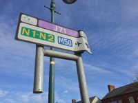
The road signs were totally revised in March 2020. The new signs focus on directions to car parks instead of "city centre", and on directions to the M50 instead of listing every radial route. Dublin Port and Dublin Airport are included too. Finally, each radial route is allowed to specify one suburb that it passes on its route out of town.
The new signs don't provide detail on other radial routes other than the one immediately available, and don't provide detail on how to follow the orbital route, which makes the function of the orbital route somewhat redundant.
Route
Although the route wasn't created until 2002, it is very similar to what was proposed in 1965.
The General Traffic Plan recommended the construction of a Canal Ring Road, utilising the canals which were in a poor state. On the south side (Grand Canal), this would have involved covering the canal, to create a D3 with two local access roads.
On the north side, a new tunnel would have been built under Phoenix Park, cutting the corner between Islandbridge and Cabra. East of Phibsborough, a one way system would have been in place, with westbound traffic using North Circular Road and eastbound traffic running on top of the Royal Canal.
Where the two roads met at Spencer Dock, a D4 would have led to a new Liffey Bridge. The road at Kilmainham did not need many upgrades, as cross-city traffic hadn't yet been considered an issue.
In 1971, the northern section of the route was replaced by the Royal Canal Motorway, which would have had a large interchange with the southern section at Grand Canal Dock. An alternative was developed which had a number of GSJs along the route. A study found that the Grand Canal Dock would have been congested as a D3, not to mention unpopular with the locals. The plan was reduced to a landscaped D2 on the basis that this would be more acceptable and less attractive, with other new roads soaking up the traffic instead. Again no provision was made for the two canal roads to meet on the western side.
Neither road was built, and today the orbital continues to utilise existing roads. Despite being entirely at-grade, there are two elaborate signalised junctions along the route, at Irishtown and Islandbridge.
Original Version
The route was created in August 2002, with junction numbering starting at J1. This caused severe confusion with the Inner Orbital.
Crossing the River Liffey near its mouth at the eastern end of Dublin has always been a difficulty for traffic planning, and the Outer Orbital had the same problem. It crossed the Liffey using Tom Clarke Bridge, which suffers from congestion. To get from here to the main part of the orbital, it then needed to cross the narrow London Bridge, and then head under a low bridge on Bath Avenue.
Dublin City Council had been expecting the junction numbers to be promoted by local businesses. Following resistance from residents, a public information campaign was launched. However just a few weeks later - and with only an estimated 50 out of 500 road signs erected - the project was stopped following complaints from the Department of Transport.
The scheme's introduction cost €200,000.
Second Version

Changes were finally made in October 2003.
The route stayed the same, but now the junction numbers started at J51, to avoid confusion with the Inner Orbital. J51 was at Beggar's Bush, and the junctions then made their way clockwise, round to J81 in Irishtown. 10 junctions (J41 through to J50) were not allocated, to totally avoid any confusion.
The new numbering included provision for three new junctions to be added. This happened in 2009, when Samuel Beckett Bridge opened and created a new route across the River Liffey towards the east of the city. The new junctions were J76, J77 and J78, and formed the new mainline of the Orbital, avoiding all of the issues mentioned previously.
As a result, the Outer Orbital now appeared to split into two at the eastern end, with the choice between the new junctions mentioned above or the old junctions, numbered J79, J80 and J81. However there was a new problem: the opening of Samuel Beckett Bridge caused the right turn from North Wall Quay into Guild Street to be banned, making the original anti-clockwise Orbital Route impossible to follow.
There were several routes to evade that turn ban available, but these were never signed. Instead, that route was allowed to continue, with its junctions still advertising their numbers, but each junction no longer provided directions to the next junction - perhaps masking the fact that this section couldn't be followed.
The rethink cost €20,000, and took place with support from the Department of Transport, who added the signs to the Traffic Signs Manual.
March 2020 Rethink
The system was overhauled in March 2020. This moved the start point (J51) to Samuel Beckett Bridge, an obvious landmark, and continued clockwise round to J80. Two new junctions were added, pointing to areas of the Docklands which had been recently regenerated. As a result, all junction numbers were changed slightly.
More importantly, the old route over Tom Clarke Bridge was formally removed from the system, and not acknowledged in the junction numbering. Between the Inner and the Outer Orbital Routes, there are now three unallocated junction numbers (J48, J49 and J50). Ironically, these could be applied to the Tom Clarke Bridge route without issue, but that's just a coincidence.
Exact Route

Starting from J51, the route of the Orbital is:
- Cardiff Lane
- Macken Street
- Grand Canal Street Lower
- Grand Canal Street Upper
- Haddington Road
- Mespil Road
- Grand Parade
- Canal Road
- Grove Road
- Parnell Road
- Dolphin Road
- Suir Road
- South Circular Road
- Conyngham Road
- Infirmary Road
- North Circular Road
- Portland Row
- Seville Place
- Guild Street
Junction List
| Image | Name | Classified Road(s) | Grid Reference | More Info | Map |
|---|---|---|---|---|---|
|
J51 | R813 | O172343 | Preceded by J80. Formerly J76. Now the start of the route. | |
|
J52 | R802 · R813 | O172339 | Formerly J77. | |
|
J53 | R815 | O172336 | Formerly J78, and the end of the route. | |
|
J54 | R111 · R815 | O176333 | Formerly the starting point, J51. | |
|
J55 | R111 · R118 | O174332 | Formerly J52. | |
|
J56 | R111 · R816 | O170329 | Formerly J53. | |
|
J57 | R111 · R138 | O165327 | Formerly J54. The junction number applies to the entire Sussex Terrace complex. Very close to Inner Orbital J13. | |
|
J58 Charlemont Bridge | R111 · R117 | O160325 | Formerly J55. | |
|
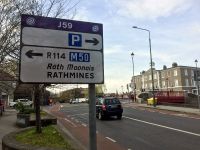
J59 La Touche Bridge | R111 · R114 | O157325 | Formerly J56. | |
|
J60 Emmett Bridge | R111 · R137 | O149324 | Formerly J57. | |
|
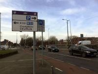
J61 Camac Bridge | R110 · R111 | O137326 | Formerly J58. | |
|
J62 | R111 · R812 | O129331 | Formerly J59. | |
|
J63 | R111 · R811 | O128334 | Formerly J60. | |
|
J64 | R111 · R810 | O128336 | Formerly J61. | |
|
J65 | R111 · R839 | O128337 | Formerly J62. | |
|
J66 | R111 · R138 | O127339 | Formerly J63. | |
|
J67 | R109 · R111 | O127344 | Formerly J64. | |
|
J68 | R101 · R109 | O136344 | Formerly J65. | |
|
J69 | R101 · R806 | O137353 | Formerly J66. | |
|
J70 Hanlon's Corner | R101 · R805 | O140354 | Formerly J67. | |
|
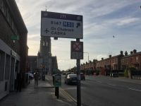
J71 | R101 · R147 | O149359 | Formerly J68. Well known for St Peter's Church standing in the middle. | |
|
J72 Doyle's Corner | R101 · R108 | O150359 | Formerly J69. | |
|
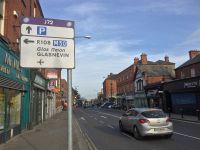
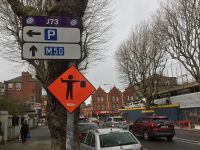
J73 | R101 · R132 | O158358 | Formerly J70. | |
|
J74 | R101 | O160357 | Formerly J71. Generally refers to Carolan's Corner on North Circular Road, but some signs apply this junction number to both ends of Belvidere Road. | |
|
J75 | R101 · R803 | O166355 | Formerly J72. Very close to Inner Orbital J37. | |
|
J76 Five Lamps | R101 · R105 | O166355 | Formerly J73. Named after the monument at the junction, which was temporarily moved to Connolly station and inspired a replica in the offices there. | |
|
J77 | R101 | O169349 | Unnumbered until 2020. | |
|
J78 | R101 | O172348 | Formerly J74. | |
|
J79 | O171346 | Unnumbered until 2020. | ||
|
J80 | R801 | O172345 | Succeeded by J51. Formerly J75. |
Former Junctions
| Image | Name | Classified Road(s) | Grid Reference | More Info | Map |
|---|---|---|---|---|---|
|
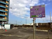
J79 | R131 · R801 | O181344 | Succeeded what was then known as J75, but since 2009 that journey cannot be done anti-clockwise. Signs were provided on the roundabout to avoid confusion with the port signage. | |
|
J80 Sean Moore Roundabout | R131 | O191338 | Signs were provided on the roundabout itself, and not the approach. This was the only junction to have a branded ADS, which technically wasn't permitted. | |
|
J81 | R111 · R131 · R802 | O186334 | The original end of the route, succeeded by what was then known as J51. |


