M32 (Republic of Ireland)
Jump to navigation
Jump to search
| M32 | ||||||||||
| Location Map ( geo) | ||||||||||
| ||||||||||
| Malahide Road | ||||||||||
| From: | Turnapin Interchange (O178415) | |||||||||
| To: | Clonshagh Bridge (O184415) | |||||||||
| Distance: | 0.5 km (0.3 miles) | |||||||||
| Met: | M50, N32 | |||||||||
| Now part of: | R139 | |||||||||
| Traditional Counties | ||||||||||
| Route outline (key) | ||||||||||
| ||||||||||
| Junction List | ||||||||||
| ||||||||||
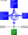
The M32 was a short motorway which branched from the M50/M1 interchange to the very first junction at Clonshaugh. This section of road was part of the N32, but under motorway regulations, as the roundabout it joined was under motorway regulations.
The road opened on 6 December 1996, as part of the Northern Cross Route Extension. The earthworks along it were described as "significant".
In 2012, the N32 was downgraded to R139. As part of the road sign changes, the M50/M1 junction was changed to no longer be under motorway regulations. In theory, the M32 was gone and it was now R139 throughout. However, despite the roundabout no longer being a motorway, the link road is now signed with blue signs calling it the M50!
Links
Pathetic Motorways


