A232 (Isle of Man)
Jump to navigation
Jump to search
| A232 | ||||
 | ||||
| Via: | Links Close, Peel | |||
| Distance: | 0.1 miles (0.1 km) | |||
| Primary Destinations | ||||
| Highway Authorities | ||||
| Traditional Counties | ||||
| Route outline (key) | ||||
| ||||
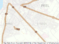
The A232 was apparently a short route in Peel, identified on the Isle of Man Government's MANNGIS GIS system. However, it was presumably a mapping error for C232 as it is a small cul-de-sac that links a C road to a handful of houses. Following updates to the system it is indeed now marked as the C232.
| A232 (Isle of Man) | ||||
| ||||
| ||||
| ||||
|
