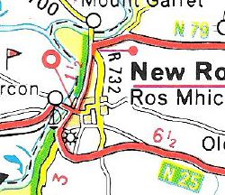
N79
| N79 | ||||
 | ||||
| From: | Enniscorthy (S970394) | |||
| To: | New Ross (S728269) | |||
| Distance: | 33.1 km (20.6 miles) | |||
| Met: | N11, N25 | |||
| Former Number(s): | T7 | |||
| Now part of: | N30 | |||
| Traditional Counties | ||||
| Route outline (key) | ||||
| ||||
The N79 was the number allocated to the road between Enniscorthy and New Ross upon the classification of N roads in 1977. It was upgraded to National Primary Road and renumbered the N30 in 1994.
Route
Throughout its existence as the N79, the route ran from the one-way system in Enniscorthy's characterful town centre. It began on the western bank of the River Slaney on the N11, the main road from Dublin to Rosslare, at the end of the Seamus Rafter Bridge. Running through Abbey Square, it promptly turned left within sight of Enniscorthy Castle, to follow Mill Park Road and Saint Johns Road, before bridging the River Urrin close to its convergence with the Slaney. The road then headed for the country along Mill Road (this route is now numbered R744).
From the recent Templscoby Roundabout, the N79 followed what is today the N30 as far as New Ross, passing through Clonroche along the way. It passed some way to the north of the new Corcoran's Cross Roundabout, and entered the town running in close proximity to the River Barrow. After cutting a meander in the river, the N79 ran down the east bank of the river into the town centre on Craywell Road (now the R700), before terminating on what was then the N25 next to the O'Hanrahan Bridge.
History
The route was originally mostly part of the T7 route from Dublin to Waterford (which used the N11 to the north of Enniscorthy and the N25 to the south of New Ross.
This page includes a scan of a non-free copyrighted map, and the copyright for it is most likely held by the company or person that produced the map. It is believed that the use of a limited number of web-resolution scans qualifies as fair use under United States copyright law, where this web page is hosted, as such display does not significantly impede the right of the copyright holder to sell the copyrighted material, is not being used to generate profit in this context, and presents information that cannot be exhibited otherwise.
If the copyright holder considers this is an infringement of their rights, please contact the Site Management Team to discuss further steps.

