Aylesbury
Jump to navigation
Jump to search
| Aylesbury | |||
| Location Map ( geo) | |||
 | |||
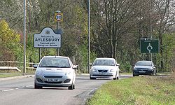
| A41 enters Aylesbury | |||
| |||
| County | |||
| Buckinghamshire | |||
| Forward Destination on | |||
| A41, A413, A418, (A4010) | |||
| Next Primary Destinations | |||
| Amersham • Banbury • Hemel Hempstead • High Wycombe • Milton Keynes • Oxford | |||
| Other Nearby Destinations | |||
| Bicester • Buckingham • Leighton Buzzard • Princes Risborough • Thame • Tring • Wendover | |||
| Places related to the A41 | |||
Wolverhampton • Solihull • Birmingham • Watford • Hemel Hempstead • Central London • London • Brent Cross • West End • Chester • Warwick • West Bromwich • Whitchurch • Birkenhead • Tring • Bicester • Ellesmere Port • Banbury • Bilston • Wednesbury | |||
| Places related to the A413 | |||
| Places related to the A418 | |||
Aylesbury is the County Town of Buckinghamshire, well known for its ducks and Friary. It's one of the largest un-bypassed towns in the UK, and one of the few that isn't on the coast. It was the site of a trial of a Tiger Crossing (a zebra crossing also for cyclist use)
Routes
| Route | To | Notes |
| London, Hemel Hempstead, Watford, Aston Clinton, Tring | different destinations on different signs | |
| (M40), Bicester, Waddeston, Banbury | ||
| London, Amersham, Wycombe (A4010) | ||
| L. Buzzard, Milton Keynes | MK via A4146 | |
| Princes Risborough, Wycombe | Accessed via A413 | |
| Buckingham | ||
| (M40), Oxford, Thame, Stone, Bicester | Avoiding Low Bridge | |
| western side of ring road | ||
| route around the north of the town | ||
| Stoke Mandeville Hospital, Stoke Mandeville, High Wycombe (A4010) | ||
| in town centre, renumbered in 1935 | ||
| Hemel Hempstead(A41), L. Buzzard, Milton Keynes (A418) | ||
| East side of future box of distributor roads | ||
| North side of future box of distributor roads | ||
| West side of future box of distributor roads | ||
| South side of future box of distributor roads |
Gemstone Cycle Routes
Cycle Aylesbury has created several signed cycle routes, named after Gemstones each with a different colour.
- Amber Way (Orange, from the southeast): From Wendover, along the B4009 and A413 into the town centre via Bedgrove and Walton
- Aqua Way (Sky Blue, from the north): From Watermead into the town centre via Elmhurst and Manor Park
- Emerald Way (Green, from the west): From Haydon Hill, via Fairford Leys and the station into the town centre.
- Jet Way (Black, from the south): From Stoke Mandeville, along the B4443, past the hospital, over the railway into Southcourt then into the town centre via the station
- Pearl Way (Lilac, from the southwest): From Hartwell, down the the A418, along the A418 until over the railway, then across to the station and into the town cente.
- Pebble Way (Brown, from the southwest): From Stone, along the A418 to the edge of town, then to the town centre via Prebendal Farm and the station
- Ruby Way (Red, from the west): From Meadowcroft, along the A41 to near the station then into the town centre.
- Sapphire Way (Blue, from the northeast): From Bierton, along the A418 and into the town centre
- Topaz Way (Yellow, from the south): From Hawkslade, through Walton Court and Southcourt, into the town centre via the station.
Links


