C110 (Newcastle upon Tyne)
| C110 | ||||
| Location Map ( geo) | ||||
 | ||||
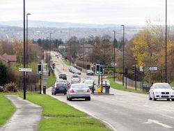
| View south from Hillhead Road in Westerhope | ||||
| ||||
| From: | Westerhope (NZ191676) | |||
| To: | Lemington (NZ182646) | |||
| Distance: | 2.4 miles (3.9 km) | |||
| Meets: | B6324, C111, A69, B6528, A6085 | |||
| Highway Authorities | ||||
| Traditional Counties | ||||
| Route outline (key) | ||||
| ||||
For other roads numbered C110, see C110.
The C110 is a short road in western Newcastle upon Tyne. It begins at traffic lights on the B6324 Stamfordham Road in Westerhope and heads southwards along Hillhead Road. As an open suburban road it rises over a crest with great views towards the south, before descending and reaching West Denton Interchange on the A69. The B6528, which carries the pre-bypass route of the A69 through Throckley and Heddon-on-the-Wall, is also met here.
Beyond the roundabout the C110 continues as Union Hall Road, descending gradually - and then more steeply - down towards the Tyne. It passes through a series of mini-roundabouts and becomes narrower and more built-up before giving way at a T-junction on Tyne View. This was once a dog-leg of the A6085 but was bypassed in the 1960s, with the C110 extending along it in both directions. The western branch bends sharply around to the left before meeting the A6085 at a roundabout, while the eastern branch passes the site of the disused Lemington Station before snaking downhill to meet the A6085 at a T-junction.
| C110 (Newcastle upon Tyne) | ||||||||||||
| ||||||||||||
| ||||||||||||
|


