C508 (Sunderland)
| C508 | ||||
| Location Map ( geo) | ||||
 | ||||
| Washington Road | ||||
| ||||
| From: | Southwick (NZ381583) | |||
| To: | Town End Farm (NZ343596) | |||
| Distance: | 2.9 miles (4.7 km) | |||
| Meets: | A1290, C551, C507 | |||
| Former Number(s): | B1289, B1290 | |||
| Highway Authorities | ||||
| Traditional Counties | ||||
| Route outline (key) | ||||
| ||||
For other roads numbered C508, see C508.
The C508 is the number given to a large section of the former B1289 in Sunderland, running from the northern end of the Queen Alexandra Bridge west to the edge of the city. It forms the 'missing' section of the A1290, the upgrade of the B1289 in both Washington and Monkwearmouth. This section was downgraded rather than upgraded, presumably to discourage traffic from using it as a through route.
It begins at a large roundabout on the A1290 to the north of the Queen Alexandra Bridge, heading north along Northern Way. This is the only section of the route that was not originally the B1289; it was the northern end of the B1290, which turned right up Church Bank to meet the B1289. Road numbering is quite confused in this area, not helped by signage which is either outdated or just plain wrong.
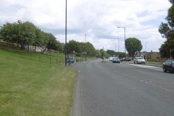
What is certain is that the C508 follows Northern Way to a large roundabout where it turns left onto North Hylton Road, passing through a residential area followed by a large industrial estate. The carriageway is quite wide, with a definite B-road feel. Past the industrial estate, North Hylton Road becomes Washington Road, with a large expanse of grass to the right and the open country of Hylton Dene to the left. The steepness of the valley is quite apparent on both sides of the road. The road passes the ruined tower of Hylton Castle and the surroundings become more built-up, with large suburban residential estates on both sides although the road is still flanked by wide grass verges and occasional trees.
Eventually the road reaches the end of the urban area and begins to curve to the right. The B1289 used to run straight on here, but that route has been truncated by the A19 with only a footbridge preserving the right-of-way. The C508 continues on the modern route of the road until it reaches the local authority boundary, just short of Downhill Lane Interchange.
| C508 (Sunderland) | ||||||||||||
| ||||||||||||
|


