C517 (Sunderland)
| C517 | ||||||||||
| Location Map ( geo) | ||||||||||
 | ||||||||||
| Burdon Lane | ||||||||||
| ||||||||||
| From: | Ryhope (NZ408530) | |||||||||
| To: | Fencehouses (NZ323499) | |||||||||
| Distance: | 6.2 miles (10 km) | |||||||||
| Meets: | B1286, A690, A182, A1052 | |||||||||
| Highway Authorities | ||||||||||
| Traditional Counties | ||||||||||
| Route outline (key) | ||||||||||
| ||||||||||
For other roads numbered C517, see C517.
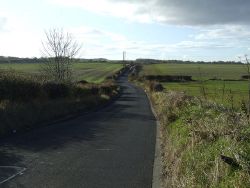
The C517 is a mostly rural road to the south and west of Sunderland. It begins on the B1286 in the Ryhope area of the city and runs slightly uphill, flanked by houses for around half a mile before the gradient increases and the character of the road changes abruptly into a narrow country lane. It continues in this vein for a couple of miles before curving left and crossing over the A19 without a junction. The C517 then immediately has to TOTSO right to resume its westerly course; approaching this junction from the other direction, the road is signed - bizarrely and wrongly - as the B1404.
The C517 continues through open fields until it reaches the staggered crossroads at Stoneygate, where it meets the A690. This is notorious locally as an accident blackspot and was remodelled in late 2016 or early 2017, meaning that traffic can no longer turn right from either approach on the C517 onto the dual carriageway A-road. As a result, the C517 cannot be driven as a through route because doing so would involve a right-left dogleg along the A690.
West of Stoneygate, the C517 runs along High Lane into Newbottle, the first built-up area on its route since leaving Ryhope. It crosses the A182 at traffic lights in the centre of the village then runs downhill along Coaley Lane and Sedgeletch Road. At Sedgeletch it bends round to the left, crossing a stream, before straightening out and entering Fencehouses. It runs straight along a residential street before ending at traffic lights on the A1052.
| C517 (Sunderland) | ||||||||||||
| ||||||||||||
|


