St James Interchange

St James' Interchange is junction 29 (formerly junction 10) of the M8. It is a substantial roundabout interchange crossed by the A726 and marking the northern end of the A737. It has been changed several times since it first opened in the 1960s, and no includes free-flowing slip roads from the M8 to the A737, which are numbered separately as junction 28A. To further complicate matters, the construction of J28A means that St James Interchange now also forms part of J28, Glasgow Airport Interchange.
The roundabout, which sits above the M8, is egg shaped to accommodate two arms to the south and one to the north of the motorway. To the north, the A726 curves back on itself to navigate around the airport perimeter, while to the south it continues south east into Paisley. The A737, meanwhile, bypasses Paisley to the west. The free flow connection between the A737 and city bound M8 passes to the south of the roundabout, bridging over the A726, and provides two lanes in each direction. While the M8 is notorious for having on and offslips almost meeting, the addition of J28A led to changes to J28. As a result, there are no longer any direct west facing slips for J28, traffic instead having to use the lengthy sliproads, which run outside the A737 slips, between J28 and J29. Heading east, this is perhaps beneficial for traffic heading into the airport, but it does add an extra junction for westbound traffic. These sliproads are two lanes apart from the westbound merge into the M8 slips just before the roundabout, which had been hatched down to a single lane.
The roundabout itself is, perhaps surprisingly, only partially signalised. The two M8 offslips and the southern arm of the A726 have traffic lights controlling access onto the roundabout. There are then two circulatory lanes, with a third on the southern flank between the M8 and A737. The Westbound M8 offslip and northbound A726 have three approach lanes, all other arms have two.
Routes
| Route | To | Notes |
| Greenock, Erskine Bridge (M898) | ||
| Glasgow | ||
| Irvine, Johnston, RA Hospital | ||
| Bishopston (A8), Erskine, Inchinnan | ||
| East Kilbride, Paisley | ||
| Glasgow Airport | Sanderling Parkway | |
| Johnston (A737), Linwood (A761) | now A737 | |
| Greenock | now M8 | |
| Glasgow | now M8 | |
| Irvine (A737), Johnston, Linwood, East Kilbride | now A737 |
Strip Maps
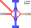
St James Interchange as it was in 1968
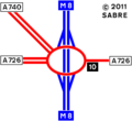
St James Interchange as it was in 1972
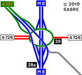
The current layout of the junction.


| St James Interchange | ||
| ||
|
_Gordon_Dowie_-_Geograph_-_1817363.jpg)