A12 (Northern Ireland)
| A12 | |||||||||||||||||||
| Location Map ( geo) | |||||||||||||||||||
| |||||||||||||||||||
| Westlink | |||||||||||||||||||
| From: | Milltown (J319730) | ||||||||||||||||||
| To: | Yorkgate (J340753) | ||||||||||||||||||
| Distance: | 2 miles (3.2 km) | ||||||||||||||||||
| Meets: | M1, B38, A501, A6, A2, M2, M3 | ||||||||||||||||||
| Primary Destinations | |||||||||||||||||||
| Highway Authorities | |||||||||||||||||||
| Traditional Counties | |||||||||||||||||||
| Route outline (key) | |||||||||||||||||||
| |||||||||||||||||||
| Junction List | |||||||||||||||||||
| |||||||||||||||||||
Route
The A12 is the Westlink in Belfast. It is a Special Road throughout, despite not being a motorway.
The A12 forms an important link between the M1 and the M2 and M3, as well as acting as a distributor in west-central Belfast. It is home to the British Isles' only Single Point Urban Interchange (SPUI), at the junction with the Divis Street.
With previous plans to build an Inner Ring Motorway scrapped, the Westlink was built in order to disperse M1 traffic, which mostly funnelled down the inadequate Donegall Road to the also inadequate A1, and M2 traffic, where the wide foreshore motorway just turned into city streets. A partially at-grade dual carriageway, the Westlink, was built on the line of the Inner Ring - linking the M1 and M2 and creating a 'throughpass' for the city as well a way of dispersing this traffic over several routes. This was fully grade-separated and declared a special road in the late 2000s.
Pictures
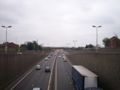
Here is the A12 Westlink as it was in June 2007.
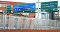
This is the end of the A12 Westlink.
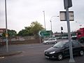
An A12 (NI) flag sign pointing South towards the M1 (NI). This is found at the Northern end of the road.

_-_Geograph_-_1625898.jpg)
.JPG)
Links
Roads.org.uk
Mótarbhealaí
Motorway Archive
Northern Ireland Road Site
legislation.gov.uk
_-_Geograph_-_498788.jpg)
_-_Geograph_-_1587230.jpg)


_-_Geograph_-_2488287.jpg)