M5 (Northern Ireland)
Jump to navigation
Jump to search

| M5 | |||||||||||||||||||
| Location Map ( geo) | |||||||||||||||||||
| |||||||||||||||||||
| From: | Greencastle (J344792) | ||||||||||||||||||
| To: | Rushpark (J351814) | ||||||||||||||||||
| Distance: | 1 miles (1.6 km) | ||||||||||||||||||
| Meets: | M2, A2 | ||||||||||||||||||
| Primary Destinations | |||||||||||||||||||
| Highway Authorities | |||||||||||||||||||
| Traditional Counties | |||||||||||||||||||
| Route outline (key) | |||||||||||||||||||
| |||||||||||||||||||
| Junction List | |||||||||||||||||||
| |||||||||||||||||||
The M5 is a short motorway bypassing the Shore Road between Greencaste and Rushpark. It was part of a planned Belfast - Carrickfergus motorway.

The M5 heading along the Foreshore towards Belfast
Taking the inner-most four lanes (2 each way), and thus making the M2 TOTSO, the M5 heads north along the reclaimed Foreshore Embankment, before briefly heading inland to end on the A2 Shore Road. From there the motorway was to follow the railway alignment (replacing the railway) through Newtownabbey to Carrickfergus.
Construction Photos
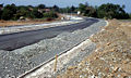
Near Rushpark, 1980
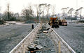
Northern terminal roundabout, 1980
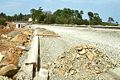
Looking north near Hazelbank Park, 1980
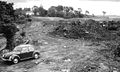
Near Hazelbank Park, 1979
_-_Geograph_-_1641995.jpg)
_-_Geograph_-_1638212.jpg)

_-_Geograph_-_1638178.jpg)
Links
Roads.org.uk
Northern Ireland Roads Site

