Drogheda
| DROGHEDA Droichead Átha | |||
| Location Map ( geo) | |||
 | |||
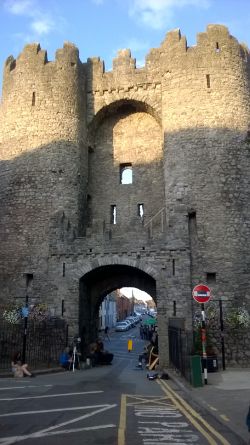
| St Laurence's Gate | |||
| |||
| County | |||
| Louth • Meath | |||
| Highway Authority | |||
| Louth County | |||
| Forward Destination on | |||
| M1, N51 | |||
| Next Terminal & Intermediate Destinations | |||
| Dublin • Dundalk • Navan | |||
Drogheda is a town in County Louth, Ireland, on the M1 corridor. The town is situated in the Boyne Valley, with the river flowing through the centre town. The river is tidal at this point, and is fairly fast flowing, as the town and docks have created a narrow pinch point in the river.
The valley is dominated by the high level Boyne Viaduct, carrying the main Dublin-Belfast railway across the town.
With the next upstream road crossing being the Slane Bridge, some 15km to the west, Drogheda has over the years developed around this important crossing point, the last before the sea.
As the main route north from Dublin, the narrow streets and crossing point at St Mary's Bridge was the cause of considerable congestion, and so in the 1970s an Inner relief road scheme was constriucted, providing a new urban dual carriageway to the south of the Boyne, and a new bridge over the river for the N1, (the Bridge of Peace). In 2003, a bypass for the town opened, with the M1 now replacing the N1 and being routed away from the town to the west. The old N1 was renumbered as R132 through Drogheda. However, this is not quite the end of the story, as the M1 itself is tolled at this point, so there is still some through traffic driving through the town (and also across the Obelisk Bridge, and even as far west as Slane) in order to avoid the toll.
Bridges
The following bridges exist through the town:
- Obelisk Bridge
- Mary McAleese Boyne Valley Bridge, which carries the M1 over the valley
- Bridge of Peace
- Dominic's Bridge (footbridge)
- Haymarket Bridge
- St Mary's Bridge, the final road crossing before the sea
- De Lacy Bridge (footbridge, named after Hugh De Lacy who granted Drogheda its town charter in 1194 - see wikipedia)
- Boyne Viaduct (railway) - see wikipedia
Port Access Northern Cross Route
A new route to provide access to the port from the motorway was agreed for construction in September 2022[1]. The road will comprise 5km single expandable carriageway, four at-grade roundabouts, new trunk watermains, new trunk foul sewer, new underpass beneath the Dublin-Belfast mainline railway, and associated earthworks[2]. It will provide access to 5000 new homes in the area. Construction started with the sod turning taking place in March 2023[3].
Routes
| Route | To | Notes |
| Áth Cliath / DUBLIN · | ||
| Béal Feirste / BELFAST · | ||
| An Uaimh / NAVAN · | ||
| An Aill / NAUL · | ||
| Baile Brigín / BALBRIGGAN | ||
| Dún Léire / DUNLEER | ||
| Baile Ui Mhornáin / MORNINGTON ·
An Inse / LAYTOWN |
||
| Baile an Bhiataigh / BETTYSTOWN | ||
| Damhliag / DULEEK | For N2 Cill Dhéagláin / ASHBOURNE | |
| Ceann Cloghair / CLOGHERHEAD | ||
| Tearmann Feichín / TERMONFECKIN | ||
| Collann / COLLON |
Links
- RTE Archives: Historic Town of Drogheda 07.04.1981 (archive.org)
References
- ↑ Independent.ie: Louth County Council signs agreement to commence Phase 1 of Drogheda’s Northern Cross Route (07.09.22) (archive.org)
- ↑ Waterman Group:North Drogheda Port Access Relief Route (archive.org)
- ↑ https://www.meathchronicle.ie/2023/03/08/northern-cross-port-route-to-support-5000-homes-north-drogheda-area/ (08.03.23) (archive.org)


