Star.pngStar.pngStar.pngStar.pngStar grey.png

Rashwood Interchange

From Roader's Digest: The SABRE Wiki
Jump to navigation Jump to search
Rashwood Interchange
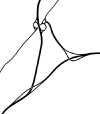
Location Map ( geo)
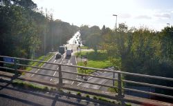
Wychavon - The A38 (C) Lewis Clarke - Geograph - 3724134.jpg
Cameraicon.png View gallery (5)
Location
Wychbold
County
Worcestershire
Highway Authority
National Highways
Junction Type
Dumbbell Hybrid
Roads Joined
M5, A38, C2004

Rashwood Interchange forms junction 5 of the M5, connecting it with the A38. The junction is a dumbbell hybrid layout, with the western roundabout taking a tear-drop shape. The slip road to the southbound M5 has a local road connecting to it, thus meaning that motorway regulations do not begin immediately at the roundabout, despite chopsticks signage in place.

History

Newspaper showing the junction when it first opened in 1962

The junction was constructed as part of the first phase of the M5, opening on Friday 20 July 1962. The initial layout was slightly different to what it is today, prior to the widening of the M5 in the early 1990s, the junction was a parclo layout, which can easily be seen from the aerial imagery. During the widening, extra slip roads were added to the north eastern and south western corners of the junction, to eliminate the loops, turning the junction into a dumbbell.

In early 2002, the eastern roundabout was enlarged to enable the construction of a new housing estate on land in the south eastern corner of the roundabout. Later in 2009, the western roundabout was modified to form a tear drop, with signals placed on the slip road from the M5. This has had a positive effect on traffic leaving the motorway northbound, queuing traffic blocking the junction causes frequent tailbacks onto the southbound carriageway. Work took place at the end of 2015 to convert the eastern roundabout into a tear drop, again with signals on the M5 slip road in a similar way to the western roundabout.

Various plans have been made in the past to construct a new link road from the junction to the Stoke Works industrial estates, bypassing the narrow country lane currently used for access. These plans, however, have been intensively opposed by local residents.


Routes

Route To Notes

M5

The NORTH, Birmingham
(M42)

M5

The SOUTH WEST, SOUTH WALES
(M50)

A38

Bromsgrove

A38

Droitwich

C2004

Stoke Works

Services

Local services are available at this junction:

East of the junction
  • McDonalds (Opened 2001)
  • Express by Holiday Inn (Opened 2001)
  • The Wych Way Inn (Opened 2004)
West of the junction
  • Travelodge


Rashwood Interchange
Related Pictures
View gallery (5)
M5 N exit.bmpA38 N.bmpRashwood M42 Southern Terminus.pngWychavon - The A38 (C) Lewis Clarke - Geograph - 3724134.jpgNewspaper - opening of the M5 Worcestershire - Coppermine - 21183.jpg
Junctions on the M5
M6 (8) Ray Hall • 1 West Bromwich • 2 Oldbury • 3 Quinton • 4 Lydiate Ash • 4A Catshill • 5 Rashwood • 6 Warndon • 7 Crookbarrow • 8 Strensham • 9 Ashchurch • 10 Piffs Elm • 11 Golden Valley • 11A Brockworth • 12 Junction 12 • 13 Stroudwater • 14 Falfield • 15 Almondsbury • 16 Almondsbury Rdbt • 17 Cribbs Causeway • 18 & 18A Lawrence Weston • 19 Gordano • 20 Clevedon • 21 St Georges • 22 Edithmead • 23 Dunball • 24 Huntworth • 25 Blackbrook • Black Brook • 26 Chelston • 27 Tiverton Parkway • 28 Cullompton • 29 Sowton • 30 Sandygate • 31 Pearce's Hill
Junctions on the A38
Bodmin - ExeterCallywith • Toll Gate House • Carminow Cross • Turfdown Roundabout • Twelvewoods Roundabout • Looe Mills • Moorswater • Island Shop • Lean Quarry • Menheniot • Trerulefoot Roundabout • Notter Bridge • Stoketon Cross • Latchbrook • Carkeel Roundabout • Saltash Town • St Budeaux • Weston Mill • Manadon • Forder Valley • Marsh Mills • Deep Lane • Voss Farm • Smithaleigh • Lee Mill • Westover • Wrangaton Cross • Woodpecker • Marley Head • Drybridge • Lower Dean • Dart Bridge • Peartree • Linhay Hill • Goodstone Cross • Drumbridges • Clay Lane • Chudleigh Station • Harcombe • Haldon • Splatford Split • Kennford • Wobbly Wheel • Pearce's Hill • Cullumpton
Tiverton - BristolTiverton Parkway • Waterloo Cross • Maiden Down • Perry Elm Roundabout • Chelston Roundabout • Chelston • Creech Castle • Walford Cross • Huntworth • Cross Rifles Roundabout • Dunball Roundabout • Edithmead • Cornhill • East Brent Roundabout • Cross • Churchill Gate Crossroads • Barrow Tanks • Lime Kiln Roundabout • Bedminster Bridge
Bristol - BirminghamSt James Barton • Filton Roundabout • Aztec West • Almondsbury Roundabout • Cross Keys Roundabout • Waterwells Roundabout • Wall's Roundabout • Coombe Hill • Gupshill Roundabout • Twyning • Rashwood • Slideshow Island • Harvester Island • Lydiate Ash • The Black Horse Junction • The Isaac Tongue Junction • Belgrave Interchange • Holloway Circus  • Paradise Circus  • St Chads Circus  • Lancaster Circus  • Dartmouth Circus • Park Circus
Birmingham - MansfieldGravelly Hill • Salford Circus • Birches Green • The Norton Crossroads • Tyburn House Island • Minworth Island • Langely Mill • Bassetts Pole • Weeford • Swinfen • Streethay • Hillards Cross • Barton Turn • Branston Junction • Clay Mills • Toyota Island • Findern • Kingsway Roundabout • Markeaton Island • Palm Court Island • Little Eaton Roundabout • Coxbench • Hartshay • Alfreton • Pinxton


SABRE - The Society for All British and Irish Road Enthusiasts
Discuss - Digest - Discover - Help