St James Barton
| St James Barton | |||
| Location Map ( geo) | |||
 | |||
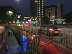
| Ramp to the subway into the Bearpit | |||
| |||
| Location | |||
| Bristol | |||
| County | |||
| Gloucestershire | |||
| Highway Authority | |||
| Bristol | |||
| Junction Type | |||
| Roundabout | |||
| Roads Joined | |||
| A38, A4044, B4051 | |||
| Junctions related to the A4044 | |||
| Junctions related to the B4051 | |||
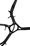
St James Barton Roundabout in Bristol is where the A38 leaves the city's inner ring road, passes under the 5102 building (flats converted from a former office block) and starts heading north up Stokes Croft and onto Gloucester Road. Whilst it is marked as a dual carriageway under the building, it is little more than the turning and merge lanes for the roundabout.
To the east of the roundabout, the A4044 follows Bond Street around the back of the Broadmead shopping centre and on to the new Cabot Circus junction. The A38 also heads south west, as the other arm of the inner ring road, and follows Haymarket around the other side of Broadmead towards the floating harbour, becoming the A4 at College Green, where the missing section of the inner ring road across Queens Square once joined.
The only other road to join the roundabout is the B4051, which climbs up the hill past the Bus Station and Bristol Royal Infirmary, running roughly parallel with the A38 (a spur heads north to terminate on Stokes Croft) before turning west to Clifton and the A4018.
The roundabout is named after the nearby St James church, with Barton simply being a medieval word for 'land retained by the person or body owning it for their own use'1.
Architecture and the Bearpit
However, the roundabout is dominated by the architecture. Not only is there the dramatic 5102 building spanning the A38, but also the back of the Debenhams building - the other side is the famous side with the diagonal escalators across the facade - the former Avon County Council HQ of Avon House, now a Premier Inn, and a number of other substantial post war edifices erected as this area of Bristol was redeveloped following wartime bombing, and subsequent clearance. All dance around the great open centre of the roundabout, known as The Bearpit. Originally designed as the pedestrian hub, connecting a series of subways it had, as is often the case, gained a poor reputation. It is said hat the name was coined by street cleaners who thought that the layout of the 1970s subway system resembled the sunken bear pits historically found in zoos.
Recent works to revitalise the area have seen sculptures and artwork installed, and the creation of a much more pleasant public open space.
Unrealised plans
Original plans for the junction from the 1960s show a north-south underpass designed to S2 standards. This was omitted from the final design. The only evidence that shows an underpass was planned is the wide central reservation beneath the 5102 building, some of which has since been used to create extra lanes leading to the roundabout.
Links
Bearpit Heritage
The Bearpit Improvement Group
BBC News
- 'Bearpit' subway in Bristol to receive £1m revamp (10.01.2012)
- Bristol 'Bearpit' subway: Views sought for £1m revamp (15.02.2012)
- Bristol 'Bearpit' sculpture marks area's regeneration (10.05.2013)
- Bristol 'Bearpit' improvement work begins (26.01.2014)
- Bristol 'bearpit' roundabout improvement delayed further (25.03.2015)
- 'No-go' fears despite £1.2m Bristol Bearpit revamp (10.11.2015)
- Businesses to quit Bristol's 'hostile' Bearpit (23.01.2018)
- Bristol Bearpit businesses to close over safety fears (20.02.2018)
References


