Star.pngStar.pngStar.pngStar.pngStar grey.png

Lydiate Ash

From Roader's Digest: The SABRE Wiki
Jump to navigation Jump to search
Lydiate Ash
Location Map ( geo)
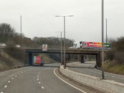
Southbound M5, Bridge at Junction 4 (C) David Dixon - Geograph - 3406617.jpg
Cameraicon.png View gallery (16)
Location
North of Bromsgrove
County
Worcestershire
Highway Authority
National Highways
Junction Type
Grade separated roundabout
Roads Joined
M5, A38, A491

Lydiate Ash is grade separated roundabout junction 4 of the M5. It originally formed the northern terminus of the first section of the M5. The junction takes its name from the hamlet to the immediate south east of the junction.

History

The old A38 at Spring Pools north of Lydiate Ash, where the M5 junction was constructed.
Temporary layout in November 1962

Before the M5 was constructed, the only main road in this area was the A459 running from the south on what is now the A38 Halesowen Road, crossing the junction slightly to the south and heading along what is now the A491 Sandy Lane (shortly after taking at TOTSO onto an S1 road.

With the opening of the M5 in July 1962, which then terminated at Lydiate Ash a roundabout was constructed with provisions for the northern extension of the M5, which came a few years later. A new D2 link road from the junction was created to meet the A38 at Rubery, bypassing the notorious bends at Spring Pools; though the final stretch to meet the M5 itself was not completed before the motorway opened, leading to a temporary initial layout. At this time, Halesowen Road to the south became part of the A38, the A459 now started from the roundabout itself.

Three years later in 1965, the M5 to the north was completed, and the A491 was connected to the roundabout following an upgrade of Sandy Lane, as a result of this, the A459 now started from the previous TOTSO junction on Sandy Lane. The re-routing of the A491 effectively formed a bypass for the villages of Fairfield and Catshill, whilst the old route is now numbered the B4091. It wasn't until the 1970s that the nearby A459 was renumbered as the B4551, and ironically received an upgrade, bypassing the old S1 stretch.

Upgrades

By the mid 1990s, the junction had become severely congested, as it was serving traffic for a large chunk of the Black Country, south west Birmingham, and Bromsgrove. The roundabout was widened to 3 lanes and traffic lights installed, though because of the layout it became notorious for accidents resulting from poor lane discipline.

In 2008, the roundabout was again exceeding its capacity, with queues regularly backing up in most directions, occasionally reaching the mainline of the motorway. In early 2009 the first phase of an improvement scheme was implemented, widening the northbound offslip and several points on the roundabout. A second phase of the scheme would have involved construction of a second roundabout to the east allowing traffic staying on the A38 to avoid the main roundabout, however this was shelved and in 2015 further widening, including physically widening the bridges took place. There is now a minimum of 4 lanes around the entire roundabout along with extended slip roads.

Unbuilt plans

M42 link

In early plans for the interchange between the M5 and M42, the northern link road would have met the M5 just to the north of Lydiate Ash, with links directly to an enlarged Lydiate Ash roundabout. Plans also show a free-flow A38 - A38 link under the roundabout. More information can be found at Pathetic Motorways


Routes

Route To Notes

M5

The NORTH WEST

M5

The SOUTH WEST, London (M40), Worcester

A38

Birmingham (South West)

A38

Bromsgrove

A491

Stourbridge

A459

Halesowen Now part of the B4551

M42

London, Solihull Abandoned Lydiate Ash link

Western
Orbital

Stourbridge, Wolverhampton Western Orbital


Lydiate Ash
Related Pictures
View gallery (16)
M42-M5 1976 - Coppermine - 708.jpgAugust 1963 - Coppermine - 19144.jpgRoadworks M5 North Junction 4 (C) Roy Hughes - Geograph - 4196881.jpgJunction 4 of M5 (C) David Smith - Geograph - 2668568.jpgAn unusual example of a bridge mounted gantry sign at M5 J4, Lydiate Ash. - Coppermine - 7506.JPG
Junctions on the M5
M6 (8) Ray Hall • 1 West Bromwich • 2 Oldbury • 3 Quinton • 4 Lydiate Ash • 4A Catshill • 5 Rashwood • 6 Warndon • 7 Crookbarrow • 8 Strensham • 9 Ashchurch • 10 Piffs Elm • 11 Golden Valley • 11A Brockworth • 12 Junction 12 • 13 Stroudwater • 14 Falfield • 15 Almondsbury • 16 Almondsbury Rdbt • 17 Cribbs Causeway • 18 & 18A Lawrence Weston • 19 Gordano • 20 Clevedon • 21 St Georges • 22 Edithmead • 23 Dunball • 24 Huntworth • 25 Blackbrook • Black Brook • 26 Chelston • 27 Tiverton Parkway • 28 Cullompton • 29 Sowton • 30 Sandygate • 31 Pearce's Hill
Junctions on the M42 and A42
M42M5 (4A) Catshill • 1 Harvester Island • 2 Hopwood Park • 3 Portway Island • 3A Umberslade • 4 Monkspath • 5 Copt Hill • 5A • 6 Bickenhill • 7 & 7A Coleshill • 8 Water Orton • 8A & 9 Dunton • 10 Junction 10 • 11 Appleby Magna
A4211 Appleby Magna • 12 Measham Road • 13 Flagstaff • 14 Junction 14 • M1 (23A) Finger Farm Roundabout
M42 Stanton Route12 M42 J12 • 13 M42 J13 • 14 M42 J14 • 15 M42 J15 • 16 M42 J16 • 17 M42 J17
M42 Lydiate Ash LinkM5 (4) Lydiate Ash
Junctions on the A38
Bodmin - ExeterCallywith • Toll Gate House • Carminow Cross • Turfdown Roundabout • Twelvewoods Roundabout • Looe Mills • Moorswater • Island Shop • Lean Quarry • Menheniot • Trerulefoot Roundabout • Notter Bridge • Stoketon Cross • Latchbrook • Carkeel Roundabout • Saltash Town • St Budeaux • Weston Mill • Manadon • Forder Valley • Marsh Mills • Deep Lane • Voss Farm • Smithaleigh • Lee Mill • Westover • Wrangaton Cross • Woodpecker • Marley Head • Drybridge • Lower Dean • Dart Bridge • Peartree • Linhay Hill • Goodstone Cross • Drumbridges • Clay Lane • Chudleigh Station • Harcombe • Haldon • Splatford Split • Kennford • Wobbly Wheel • Pearce's Hill • Cullumpton
Tiverton - BristolTiverton Parkway • Waterloo Cross • Maiden Down • Perry Elm Roundabout • Chelston Roundabout • Chelston • Creech Castle • Walford Cross • Huntworth • Cross Rifles Roundabout • Dunball Roundabout • Edithmead • Cornhill • East Brent Roundabout • Cross • Churchill Gate Crossroads • Barrow Tanks • Lime Kiln Roundabout • Bedminster Bridge
Bristol - BirminghamSt James Barton • Filton Roundabout • Aztec West • Almondsbury Roundabout • Cross Keys Roundabout • Waterwells Roundabout • Wall's Roundabout • Coombe Hill • Gupshill Roundabout • Twyning • Rashwood • Slideshow Island • Harvester Island • Lydiate Ash • The Black Horse Junction • The Isaac Tongue Junction • Belgrave Interchange • Holloway Circus  • Paradise Circus  • St Chads Circus  • Lancaster Circus  • Dartmouth Circus • Park Circus
Birmingham - MansfieldGravelly Hill • Salford Circus • Birches Green • The Norton Crossroads • Tyburn House Island • Minworth Island • Langely Mill • Bassetts Pole • Weeford • Swinfen • Streethay • Hillards Cross • Barton Turn • Branston Junction • Clay Mills • Toyota Island • Findern • Kingsway Roundabout • Markeaton Island • Palm Court Island • Little Eaton Roundabout • Coxbench • Hartshay • Alfreton • Pinxton


SABRE - The Society for All British and Irish Road Enthusiasts
Discuss - Digest - Discover - Help