Turnapin Interchange
| Turnapin Interchange Acomhal Thurnapain | |||
| Location Map ( geo) | |||
 | |||
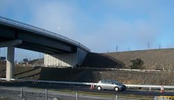
| A small part of the interchange. | |||
| |||
| Location | |||
| Clonshagh / Turnapin Little | |||
| County | |||
| Dublin | |||
| Highway Authority | |||
| Transport Infrastructure Ireland | |||
| Junction Type | |||
| Roundabout interchange + directional T | |||
| Opening Date | |||
| 1996 | |||
| Roads Joined | |||
| M1, M50, R139 | |||
| Junctions related to the N50 | |||
Turnapin Interchange is junction 1 of the M1 and junction 3 of the M50.
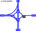
When this section of the M1 was first built, there was a single overpass carrying an unclassified road at this point. This overpass then became the northern bridge of a standard roundabout interchange when the northern cross section of the M50 was built, which opened in December 1996. The M50 approach to the junction was built with two lanes, both of which joined the roundabout.
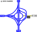
This junction had separate slips for M50 clockwise to M1 north and M50 anti-clockwise; however, in 2010 free-flow right-turn slips were built, creating a directional-T between the M1 and M50, with the old roundabout nestled inside it.
While the new layout has a high capacity, it still suffers from congestion, primarily due to traffic joining the motorway from the roundabout struggling to merge. This unusual layout, effectively a right-hand entrance, has necessitated several signs urging drivers to stay in lane.
The status of the road to the east of here, known as the Northern Cross Route Extension, has caused some confusion. It was designated N32, but the first section of it was a single carriageway road under motorway regulations, making it actually M32. The N32 became the R139 in 2012, and the road had its motorway status removed. Despite this, new signs have gone up calling it the M50! As of 2021, electronic VMS signage still refers to the exit as "N32".
Routes
| Route | To | Notes |
| Aerfort AIRPORT · Béal Feirste BELFAST | ||
| Ó Dheas SOUTHBOUND · Gach Trae Eile ALL OTHER ROUTES | For N2, N3, N4, N7 | |
| An Lár CITY CENTRE · Calafort Átha Cliath DUBLIN PORT | Via tunnel | |
| Mullach Íde MALAHIDE | Formerly N32 (quondam M32) | |
| Mullach Íde MALAHIDE | Never signed as such. |
Strip maps
| Turnapin Interchange | ||
| ||
| ||
|


