A4032
| A4032 | ||||
| Location Map ( geo) | ||||
| ||||
| From: | Bristol Parkway (ST604745) | |||
| To: | Bristol City Centre (ST593735) | |||
| Distance: | 0.7 miles (1.1 km) | |||
| Meets: | M32, A4320, A4044 | |||
| Former Number(s): | B4050 | |||
| Highway Authorities | ||||
| Traditional Counties | ||||
| Route outline (key) | ||||
| ||||
For the former A4032 in Worcestershire, see A4032 (Hagley).
Route
The A4032 provides the link from the M32 to the A4044 Bristol Inner Circuit and so Bristol City Centre.
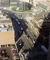
The road starts on St Agnes Roundabout, which is part of J3 of the M32 and is also the junction for the A4320 Bristol Outer Circuit road and the B4051. The road goes down the southern sliproads from the roundabout and takes over from the M32 into the city. Almost immediately, a bus lane appears on the inside of the southbound carriageway. The road finishes at a large signalised junction with the A4044, next to Cabot Circus shopping centre.
Some maps show the A4032 carrying under St Agnes roundabout before suddenly becoming the M32, but travelling out of Bristol, the signs showing the start of the motorway are immediately after the start of the sliproad up to St Agnes roundabout, indicating that the road under the roundabout is the M32. However, on the north side of the roundabout, the start/end of motorway signs are halfway down the sliproads down to the M32, because there are road junctions on both sliproads - Mina Road on the northbound side and Millpond Street on the southbound side. The 1:50,000 OS map shows the roads between the roundabout and these junctions to be a primary A-road, but it is unclear whether these are actually the A4032 or A4320.
History
The M32 was originally intended to run all the way to the Inner Circuit Road and end at a freeflowing directional-T interchange. This section of the motorway would have been elevated for its entire length south of Junction 3.
By the time the southern section of the M32 was ready for construction the plan had altered considerably. The M32 was to pass below Junction 3 rather than above it. More significantly the section south of Junction 3 was downgraded to an all-purpose dual carriageway at ground level. This was built at the same time as the last section of the M32, both of which opened in May 1975. The road first parallels Newfoundland Road and then takes over the course of the road for the last third. The western side of the road is the original edge of Newfoundland Road. The new road was called Newfoundland Way, with the remaining parts of Newfoundland Road forming a local road. Had the original M32 proposals came to fruition Newfoundland Road would have remained intact as a single carriageway with the M32 overlooking it nearby.
The route as built overall largely matches that of the former B4050 which, beginning at a junction with the A38 at the Haymarket in the city centre, ran along the Horsefair, then Milk Street (now obliterated by the A4044), Newfoundland Street, and Newfoundland Road before ending on the B4051 (Lower Ashley Road) at a point now located on the eastern edge of the St Agnes roundabout (J3 of the M32).
To provide space for the new road, several hundred houses between Newfoundland Road and the River Frome were demolished. Only half of the demolished houses were actually built on by the road, but with the river on the eastern side, the new road truncated all the access roads. The space not taken by the new road was converted into River Park, providing a lot of greenery on the eastern side of the road.
When built, the road finished at one side of a large T-junction with the A4044 Bond Street, forming part of the Bristol Inner Circuit road. In 2007, the junction with the A4044 was moved back 200 yards along the A4032, to allow the building of the new Cabot Circus shopping development. A new link road, Bond Street South, was built looping back to the original A4044 route. To provide access to the huge new car park for Cabot Circus, the last 100 yards or so of the A4032 was made into a gyratory system called Newfoundland Circus. This also provided access for traffic travelling clockwise around the A4044 Bristol Inner Circuit as no direct access for this movement was provided at the main A4032/A404 junction.
In 2008, the Newfoundland Way part of the road was rebuilt to allow a bus lane to be added on the inside of the southbound carriageway. This was done by narrowing the central reservation and widening both carriageways slightly, but still within the road boundary.


