Star.pngStar.pngStar grey.pngStar grey.pngStar grey.png

A4176

From Roader's Digest: The SABRE Wiki
Jump to navigation Jump to search
A4176
Location Map ( geo)
Cameraicon.png View gallery (1)
From:  Hotwells (ST562733)
To:  Durdham Down (ST572748)
Distance:  1.2 miles (1.9 km)
Meets:  A4, B4467, A4018
Former Number(s):  B4468
Primary Destinations
Highway Authorities

Bristol

Traditional Counties

Gloucestershire

Route outline (key)
A4176 Hotwells - Durdham Down, Bristol
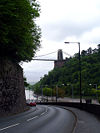
Bridge Valley Road approaching the A4

The A4176 is a short A-road to the west of Bristol city centre.

The road starts on the A4 in the shadow of the Clifton Suspension Bridge at such a sharp angle that there is only access between the A4176 and the A4 to/from the south. The road runs up Bridge Valley Road alongside and parallel to the A4 for the first 100 m or so, albeit starting the climb out of the Avon Gorge, meaning that links between the A4 in the other direction are impossible. Bridge Valley Road then diverges slightly, climbing up through the trees before turning sharply to the right and skirting along the south eastern side of Clifton Down, with the now closed former site of Bristol Zoo on the right for a short distance. After meeting the B4467 the road then ends, little more than a mile after it started, at the complex roundabout/one-way system with the A4018 at Durdham Down.

History

Bridge Valley Road was originally built in 1822 to provide improved access to the springs at Hotwells from Clifton. It later provided access to Hotwells Railway Station, where a railway ran north to Avonmouth. When the A4 Portway was built in the 1920s, it was constructed over the line of this railway.

The A4176 was originally unclassified along Bridge Valley Road and Clifton Down, while Upper Belgrave Road was the B3125. The whole route later became part of the B4468, and was upgraded to A-road in the 1970s.


A4176
Places
Related Pictures
View gallery (1)
Looking down Bridge Valley Road - Geograph - 174164.jpg
Other nearby roads
Bristol
A4 • A36 • A37 • A38 • A369 • A370 • A403 • A407 (Bristol) • A420 • A430 (Chippenham - Bristol) • A431 • A432 • A3024 (Bristol) • A3029 • A3034 (Bristol) • A4017 • A4018 • A4032 • A4044 • A4162 • A4174 • A4175 • A4320 • B3119 • B3120 • B3121 (Bristol) • B3122 • B3123 (Bristol) • B3124 • B3125 • B3126 • B3129 • B4045 (Keynsham) • B4046 • B4047 (Gloucestershire) • B4048 • B4049 • B4050 • B4051 • B4052 • B4053 • B4053 (Colston Street, Bristol) • B4054 • B4055 • B4056 • B4057 • B4058 • B4465 • B4466 • B4467 • B4468 • B4469 • E30 • E105 (London - Fishguard) • E116 (Old System) • EuroVelo 1 • EuroVelo 2 • Longest Lane • M4 • M5 • M32 • M49 • NCN4 • NCN41 • Outer Circuit Road • South Bristol Spur • T9 (Britain) • T16 (Britain)
A4100-A4199
A4100 • A4101 • A4102(W) • A4102(E) • A4103 • A4104 • A4105 • A4106 • A4107 • A4108 • A4109 • A4110 • A4111 • A4112 • A4113 • A4114 • A4115 • A4116 • A4117 • A4118 • A4119
A4120 • A4121 • A4122 • A4123 • A4124 • A4125 • A4126 • A4127 • A4128 • A4129 • A4130 • A4131 • A4132 • A4133 • A4134 • A4135 • A4136 • A4137 • A4138 • A4139
A4140 • A4141 • A4142 • A4143 • A4144 • A4145 • A4146 • A4147 • A4148 • A4149 • A4150 • A4151 • A4152 • A4153 • A4154 • A4155 • A4156 • A4157 • A4158 • A4159
A4160 • A4161 • A4162 • A4163 • A4164 • A4165 • A4166 • A4167 • A4168 • A4169 • A4170 • A4171 • A4172 • A4173 • A4174 • A4175 • A4176 • A4177 • A4178 • A4179
A4180 • A4181 • A4182 • A4183 • A4184 • A4185 • A4186 • A4187 • A4188 • A4189 • A4190 • A4191 • A4192 • A4193 • A4194 • A4195 • A4196 • A4197 • A4198 • A4199
Former iterations: A4105(W) • A4105(E) • A4108 • A4114 • A4115 • A4116 • A4125 • A4141 • A4150 • A4154 • A4160 • A4168


SABRE - The Society for All British and Irish Road Enthusiasts
Discuss - Digest - Discover - Help