A446(M)
| A446(M) | |||||||||||||||||||||||||||||||||||||||||||
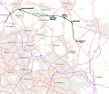
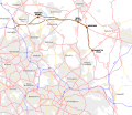
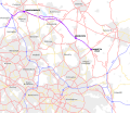
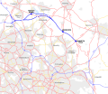
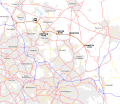
| Location Map ( geo) | |||||||||||||||||||||||||||||||||||||||||||
| |||||||||||||||||||||||||||||||||||||||||||
| From: | Coleshill (SP214867) | ||||||||||||||||||||||||||||||||||||||||||
| To: | Shareshill (SJ952076) | ||||||||||||||||||||||||||||||||||||||||||
| Distance: | 27 miles (43.5 km) | ||||||||||||||||||||||||||||||||||||||||||
| Meets: | M6, M42, A38, A453, A5, A461, A34, M6, A460, M54 | ||||||||||||||||||||||||||||||||||||||||||
| Old route now: | M6 Toll/M600 | ||||||||||||||||||||||||||||||||||||||||||
| Traditional Counties | |||||||||||||||||||||||||||||||||||||||||||
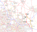
| Route outline (key) | |||||||||||||||||||||||||||||||||||||||||||
| |||||||||||||||||||||||||||||||||||||||||||
| Junction List | |||||||||||||||||||||||||||||||||||||||||||
| |||||||||||||||||||||||||||||||||||||||||||

A446(M) was the working number for the Birmingham Northern Relief Road, which was highly likely to become M6, but opened in 2003 as the M6 Toll.
History
The opening of the M5 and M6 Midland Links through the West Midlands conurbation in 1972 completed the final section of the main north-south motorways running along the western side of England. However the M6 was soon running at capacity and suffered frequent congestion. In the early 1980s it was decided a new road was needed to remove some of the traffic. Consultations were announced in 1984 with exhibitions showing the options of several routes.
The sections to the north and south of Bassetts Pole were treated separately.
Route options for the northern section
The northern section had a choice of five possible routes. Most of these routes also had variations at Brownhills where they would run near the A5 or Chasewater. Each route was appraised and ranked based on several factors. The results of the consultation favoured the green route running next to Chasewater so this was the option chosen to be developed despite its rather poor performance.
Green Route
Brown Route
Violet Route
Blue Route
Orange Route


| Route | Houses within 300m | Houses taken | Businesses taken | Schools taken | Farmland taken (hectares) | Disruption during construction | Route length M6 to Bassetts Pole km | Route length M54 to Bassetts Pole km | Effectiveness in relieving M6 | 1984 cost (millions) | Economic performance |
|---|---|---|---|---|---|---|---|---|---|---|---|
| Green | 1630 | 85 | 3 | 1 | 121.8 | 9 most | 25.8 | 28 | 6 | 102 | 9 worst |
| Green Chasewater | 1030 | 40 | 3 | 0 | 138.7 | 5 | 25.9 | 28.1 | 6 | 93 | 8 |
| Brown | 1130 | 80 | 1 | 1 | 133.7 | 8 | 26.7 | 26.2 | 8 | 94 | 6 |
| Brown Chasewater | 610 | 35 | 1 | 0 | 141.7 | 5 | 27.5 | 27 | 9 least | 89 | 7 |
| Violet | 1590 | 70 | 3 | 1 | 124.4 | 7 | 23.6 | 25.8 | 3 | 91 | 5 |
| Violet Chasewater | 990 | 25 | 3 | 0 | 139.6 | 3 | 23.7 | 25.9 | 3 | 84 | 4 |
| Blue | 1085 | 65 | 1 | 1 | 123.3 | 4 | 24.5 | 24 | 2 | 86 | 2 |
| Blue Chasewater | 570 | 20 | 1 | 0 | 142.5 | 1 least | 25.3 | 24.8 | 5 | 80 | 3 |
| Orange | 1225 | 5 | 5 | 0 | 131.6 | 2 | 24 | 23.5 | 1 most | 82 | 1 best |
Route options for the southern section
South of Bassetts Pole there were just two possible routes. The red route upgrades the existing A38 and joins the M6 at the northwest side of J4a. The yellow route follows the A446 and joins the A42 at J9. The comparison of the routes for this section is more clear cut with the yellow option being far superior on almost all counts. It's therefore little surprise that the yellow route was chosen for this section.
Red and Yellow Routes

| Route | Houses within 300m | Houses taken | Businesses taken | Schools within 300m | Farmland taken (hectares) | Disruption during construction | Route length Bassetts Pole to M6 km | Effectiveness in relieving M6 | 1984 cost (millions) | Economic performance |
|---|---|---|---|---|---|---|---|---|---|---|
| Red | 260 | 5 | 1 | 3 | 26.5 | more | 16.9 | less | 30 | worst |
| Yellow | 55 | 3 | 0 | 2 | 64.6 | less | 15.8 | more | 29 | best |
With the routes of both sections selected a preferred route was announced in 1986. However in 1987 detailed plans were drawn up for all the routes including the alternatives suggesting they may not yet be out of the running.
1987 Route

This section is going to focus on the originally planned route which was based on the green option from the 1984 consultation with some changes to the junctions in the Brownhills area. For the finalised route, see the M6 Toll article.
The original plans was for an untolled motorway. As such, junctions were more standard roundabouts and the A38 Sutton Coldfield bypass was to be upgraded mostly online between a fork at Langley Mill and Weeford. In the Brownhills area, the route was different, running north of the A5 east of Wall Island, a short bit of online upgrade of the A5, using the passive provision for a flyover at Wall Island. These online upgrades meant junctions would be provided for the A453 at Bassetts Pole and A461 at Muckley Corner.
The northern end was also different, running further south to extend a bit further: to Featherstone on the M54 (this would have been part of the Western Orbital route). This would have meant no junction with the A460 at Wedges Mills.


