M53/Unbuilt Southern Extension
| M53/Unbuilt Southern Extension | |||
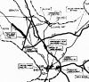
| Location Map ( geo) | |||
| |||
| From: | Hooton Fork (SJ351789) | ||
| To: | Backford (SJ398711) | ||
| Meets: | M53, A550, M56, A41 | ||
| Traditional Counties | |||
When the first stage of the M53 Mid-Wirral Motorway was planned and constructed between Wallasey and Hooton it was planned to extend it towards Chester. The junction was built to allow this – Hooton Fork.
History
Initial plans

It dates back to the 1960s and the route is shown on the Improvement Schemes map prepared by Cheshire County Surveyor by May 1966. It was depicted as “Other important major scheme not yet programmed” and “under consideration”. The motorway north of Hooton Fork was shown as “Programmed”.
In August 1967 Mr J.D. Wallace, Ministry of Transport's Divisional Road Engineer, stated that it would be the final stage of the Mid-Wrral Motorway, this being from Hooton to Backford Bridge on the outskirts of Chester. Here it would join the A41. Mr Wallace stated that it would follow on from the previous stage and no delay was envisaged.

Borehole tests along the route had already been completed in April and May 1967. The scans of the borehole tests are headed “Mid-Wirral Road”
At that stage there was no mention of a link to M56 since the westwards extension of that road was not on the plans.

Southwards to Chester Southern Bypass
A 1971 plan by the County Surveyor showed the extension from Hooton Fork to M56 as under consideration and then southwards as “uncommitted” to cross A41, the Ellesmere Port Motorway extension under consideration, A51, A41 and join the Chester Southern Bypass under consideration.
Opposition
In November 1972 Lea and Mollington Residents' Association prepared alternative motorway plans which they claimed would save thousands of pounds and preserve large tracts of countryside. Chester M.P., Jack Temple was so impressed with them that he passed them to Chester County Council and Transport Minister, John Peyton for consideration.
The saving would come from providing one upgrade since, as well as the M53 Southern extension to Chester, the Liverpool Echo report of 23 November 1972, mentioned a Cheshire County Council scheme from M53 at Raby (between J4 and J5) passing Burton and across the Dee Estuary.
The residents' proposed an A550 upgrade between Hooton and Shotwick instead of the M53 Southern extension and the Raby to Dee Estuary roads.
Deputation
Ellesmere Port Borough Council and Cheshire County Council were still in favour of the M53 extension and in February 1973 a deputation met John Peyton to discuss the dangers of A41 in Cheshire. The four mile stretch from Hooton was described as one of the most dangerous in the North with 4 killed and 55 injured in 45 accidents in the previous year. They asked for an early start to an extension to the Ellesmere Port Motorway to Hoole (then under construction to Little Stanney) and the M53 extension to Backford Cross.
The Minister agreed to look at the proposals “very carefully and sympathetically”. It did result in two pelican crossings in Little Sutton but the motorway schemes were still under consideration.
Ellesmere Port Motorway Extension
The Ellesmere Port Motorway extension to Hoole came up when the Government announced in March 1973 that the Chester Southern Bypass would start in Spring 1974. It was described as the "missing link” but Cheshire County Council said that no line had been fixed and the proposals were tentative.
However, it moved fairly quickly and in May 1973 Chester County Council put forward their £14 million proposals for a 6 mile extension of M56 from Hapsford to Lea-by-Backford and 4 mile extension of Ellesmere Port Motorway from Little Stanney to Hoole.
This did not immediately kill off the M53 extension since a decision from the Minister was expected soon and in October 1974 it was reported that the 6 miles from Hooton to Lea-by-Beckford (i.e. to M56) was included in the preparation pool of the latest motorway programme of Department of Environment. The M56 extension was in the firm programme.
No money
In May 1975 Cheshire County Council said that there was not enough cash for the M53 extension and was to ask the Government to meet the full cost of the “essential scheme”.
Then in June 1976 it was the Government's turn to reign in funding and cut spending, with the project taken out of the Starts programme, citing reduced forecast traffic levels. The Committee told the Department of Transport to stop protecting the route on 31 March 1977. When the Ellesmere Port motorway was extended in March 1981, it took the M53 number, effectively consigning the original route to history.
Links