Star.pngStar.pngStar.pngStar grey.pngStar grey.png

Horseley Fields Junction

From Roader's Digest: The SABRE Wiki
Jump to navigation Jump to search
Horseley Fields Junction
Location Map ( geo)
Cameraicon.png View gallery (1)
Location
Wolverhampton city centre
County
Staffordshire
Highway Authority
Wolverhampton
Junction Type
Fork Interchange
Roads Joined
A454
Junctions related to the A454
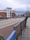
Looking eastwards at the junction

Horseley Fields Junction is located on A454 just to the east of Wolverhampton city centre.

It is a simple light-controlled fork junction between the original routing of A454 running east-west through the junction site, and the short link to Bilston Street Island with the A4150 Wolverhampton Inner Ring Road added in 1986. The link to the west forms a spur of A454 and is only two-way as far as Corn Hill. The spur is used in a westbound direction for access to Corn Hill and the High Level station; as well as the area immediately to the southwest of the junction. In an eastbound direction, the spur forms a direct link from the Inner Ring Road.

Routes

Route To Notes

A454

City Centre

A454

Willenhall, Walsall, M6

A454

link to Inner Ring Road


Horseley Fields Junction
Related Pictures
View gallery (1)
Horseley Fields - Geograph - 2908647.jpg
Other nearby junctions
Wolverhampton
Anson Junction • Battlefield Roundabout (Wolverhampton) • Bentley Bridge Island • Bentley Interchange • Bentley Junction • Bilston Street Island • Bowmans Harbour Island • Broad Street Junction • Bull Ring (Sedgley) • Bull Ring (Willenhall) • Bull Stake • Bushbury Island • Chapel Ash Island • Coseley Road Island • Coven Heath Interchange • Coven Roundabouts • Elephant and Castle (Wolverhampton) • Essington Interchange • Featherstone Interchange • Fighting Cocks • Five Ways (Dunstall Park, Wolverhampton) • Five Ways (Merry Hill, Wolverhampton) • Five Ways (Wolverhampton City Centre) • Five Ways (Wolverhampton) • Fordhouses Roundabout • Four Ashes Junction • Fox Crossroads • Gailey Interchange • Gailey Island • Goodyear Island • Keyway Junction • Laney Green Interchange • Leicester Square (Wolverhampton) • Lloyd Hill Roundabout • Merrills Hall Island • Midland Counties Dairy • Moxley Junction • Neachells Lane Island • New Cross Junction • New Invention Island • Oxford Street Island • Penn Road Island • Pickmere Roundabout • Portobello Island • Princes Square • Queen Square (Wolverhampton) • Saredon Interchange • Short Heath Interchange • Snow Hill Junction (Wolverhampton) • Spring Vale Island • St Peters Square • Stafford Place • Stafford Street Junction • Standeford Crossroads • The Dale • The Lunt Junction • Scotlands Island • Three Tuns Junction • Tong Interchange • Victoria Square • Vine Island Junction • Vulcan Road Island • Waterloo Road Junction • Western Way Interchange • Wood End Island


SABRE - The Society for All British and Irish Road Enthusiasts
Discuss - Digest - Discover - Help