The Dale
| The Dale | |||
| Location Map ( geo) | |||
| |||
| Location | |||
| Willenhall | |||
| County | |||
| Staffordshire | |||
| Highway Authority | |||
| Walsall | |||
| Junction Type | |||
| Roundabout | |||
| Roads Joined | |||
| B4464 • B4484 | |||
| Junctions related to the B4484 | |||
| Junctions related to the B4464 | |||
The Dale is located in the town centre of Willenhall, Staffordshire, and since its creation in the 1820s along the New Road, Willenhall's first bypass, it has become the transport hub of the town, where four of the five main routes out of the town - Wolverhampton to the west, Walsall to the east, Wednesfield to the north and Bilston to the south all met; with the fifth (to Cannock) meeting one of the others just a few yards away; whilst the former Willenhall Bilston Street railway station was just around 150 yards to the south.
It was also the location where at one point trolley bus services from Wolverhampton and Walsall both terminated; and passengers wishing to travel by that method between the two places were required to change.
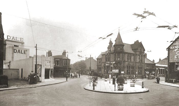
Whilst the present junction is a mini-roundabout, archive photographs show a much larger physical roundabout in place in the 1920s[1], with it lasting until at least the 1960s[2]. This was presumably removed along with the majority of through traffic in the early 1970s.
Upon classification in 1922, the classified roads that passed through the junction were the A454 on the east-west axis, and the B4157 which terminated here. Since that time, every arm of the junction has been renumbered at least once.
Routes
| Route | To | Notes |
| Wolverhampton (A454), Wednesfield (B4484) | former A454 | |
| Walsall (A454) | former A454 | |
| Bilston | former B4157 | |
| Wolverhampton | ||
| Walsall | ||
| Wednesfield | now a pedestrian zone | |
| Cannock | ||
| Bilston |
References
- ↑ Wolverhampton Heritage and History: Willenhall (1920s)
- ↑ Francis Frith (1960s)