Scotlands Island
| The Scotlands Island | |||
| Location Map ( geo) | |||
 | |||
| |||
| Location | |||
| The Scotlands, Wolverhampton | |||
| County | |||
| Staffordshire | |||
| Highway Authority | |||
| Wolverhampton | |||
| Junction Type | |||
| Roundabout | |||
| Roads Joined | |||
| A460, B4156 | |||
| Junctions related to the A460 | |||
Elephant and Castle (Wolverhampton) • Queen's Square (Cannock) • Churchbridge • Princes Square • Laney Green Interchange • Wedges Mills Interchange • Featherstone Interchange • Longford Island • Brereton Roundabout • Cat Roundabout • Globe Island • Hayes Way Island • Mill Green Island • Hawks Green Island | |||
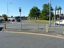
The Scotlands Island is located on the north-eastern side of Wolverhampton, in the curiously named suburb of The Scotlands. It is a six-armed roundabout located at the junction of two classified roads, the A460 between the city centre and Cannock, and the B4156 which starts here on its route eastwards to the village of Essington. The other three arms lead to the residential areas around the junction.
The eastern side of the junction is surrounded by retail properties, which are served by two service roads that run between Willow Avenue and Blackhalve Lane, and Willow Avenue and Cannock Road.
History
According to available mapping evidence, the roundabout was constructed between 1969 (as it does not appear on the relevant OS One Inch map) and 1974 (as it does appear on the first edition of the relevant OS Landranger).
Prior to that time, it appears to have been a modified crossroads similar to a Fiveways, but with six arms following the construction of the housing estates to the north and south in the 1940s and 1950s. Prior to that, it was a four-armed angled crossroads.
Routes
| Route | To | Notes |
| Cannock, M54, M6 | ||
| City Centre | ||
| Essington | ||
| Bushbury |
