Star.pngStar.pngStar.pngStar grey.pngStar grey.png

Essington Interchange

From Roader's Digest: The SABRE Wiki
Jump to navigation Jump to search
Essington Interchange
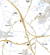
Location Map ( geo)
M6 J10a semispan gantry.jpg
Cameraicon.png View gallery (7)
Location
Essington
County
Staffordshire
Highway Authority
National Highways
Junction Type
Fork
Roads Joined
M6, M54
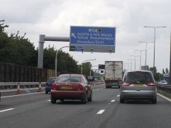
M6 southbound from the M54 overbridge

The Essington Interchange is junction 10A of the M6 motorway, and is located to the northeast of Wolverhampton.

It was opened in 1983, and is the eastern terminus of the M54. There is no access to or from the M6 to the north of the junction due to the presence of Hilton Park services immediately to the north. Anyone on the M54 wanting to go northbound on the M6 would either have to leave the M54 at Junction 2, and travel up the A449 joining the M6 at Junctions 12 or 13; or leave at Junction 1 and join the M6 at Junction 11 via the A460.

Its primary function is to allow access to main motorway network from the northern side of Wolverhampton, as well as from the former New Town of Telford and the rest of Shropshire and mid-Wales beyond.

Both B4156 and A462 pass through the junction area, but neither of them interchange with the motorway network at this location.

One of the options for the proposed M54 - M6 Toll Link Road included the addition of north-facing sliproads at this junction, which would have involved the demolition of Hilton Park services, which are located immediately to the north of this junction - however, this option was dropped following consultation.

Routes

Route To Notes

M6

The NORTH WEST & Stafford

M6

The SOUTH, Birmingham

M54

NORTH (& MID) WALES, Wolverhampton & Telford


Essington Interchange
Projects
Related Pictures
View gallery (7)
Motorway junction sign M6 - M54 - Geograph - 1896190.jpgQueue at J10a - Coppermine - 5952.jpgIMG 3929.JPGIMG 5151.JPG M6 M5 Motorway Junction.jpgBNRR M6 M54 brown blue and orange schemes.png
Other nearby junctions
Wolverhampton
Anson Junction • Battlefield Roundabout (Wolverhampton) • Bentley Bridge Island • Bentley Interchange • Bentley Junction • Bilston Street Island • Bowmans Harbour Island • Broad Street Junction • Bull Ring (Sedgley) • Bull Ring (Willenhall) • Bull Stake • Bushbury Island • Chapel Ash Island • Coseley Road Island • Coven Heath Interchange • Coven Roundabouts • Elephant and Castle (Wolverhampton) • Featherstone Interchange • Fighting Cocks • Five Ways (Dunstall Park, Wolverhampton) • Five Ways (Merry Hill, Wolverhampton) • Five Ways (Wolverhampton City Centre) • Five Ways (Wolverhampton) • Fordhouses Roundabout • Four Ashes Junction • Fox Crossroads • Gailey Interchange • Gailey Island • Goodyear Island • Horseley Fields Junction • Keyway Junction • Laney Green Interchange • Leicester Square (Wolverhampton) • Lloyd Hill Roundabout • Merrills Hall Island • Midland Counties Dairy • Moxley Junction • Neachells Lane Island • New Cross Junction • New Invention Island • Oxford Street Island • Penn Road Island • Pickmere Roundabout • Portobello Island • Princes Square • Queen Square (Wolverhampton) • Saredon Interchange • Short Heath Interchange • Snow Hill Junction (Wolverhampton) • Spring Vale Island • St Peters Square • Stafford Place • Stafford Street Junction • Standeford Crossroads • The Dale • The Lunt Junction • Scotlands Island • Three Tuns Junction • Tong Interchange • Victoria Square • Vine Island Junction • Vulcan Road Island • Waterloo Road Junction • Western Way Interchange • Wood End Island
Junctions on the M6
PresentM1 J19 Catthorpe • 1 Junction 1 • 2 Ansty • 3 Exhall • 3A/4 Coleshill • 4A Water Orton • 5 Castle Bromwich • 6 Gravelly Hill • 7 Great Barr • 8 Ray Hall • 9 Wednesbury • 10 Bentley • 10A Essington • 11 Laney Green • 11A Saredon • 12 Gailey • 13 Dunston • 14 Creswell • 15 Hanchurch • 16 Barthomley • 17 Sandbach • 18 Middlewich • 19 Tabley • 20 Lymm • 21 Woolston • 21A Croft • 22 Winwick • 23 Haydock Island • 24 Junction 24 • 25 Bryn • 26 Orrell • 27 Junction 27 • 28 Leyland • 29 Bamber Bridge • 30 Blacow Bridge • 31 Samlesbury • 31A Haighton • 32 Broughton • 33 Hampson Green • 34 Lune Valley • 35 Carnforth • 36 Crooklands • 37 Killington • 38 Tebay • 39 Shap • 40 Skirsgill • 41 Catterlen • 42 Golden Fleece • 43 Rosehill • 44 Kingstown • 45 Guards Mill
Former32A Broughton Roundabout • 35A Keer Level Roundabout
Unbuilt"6A" Perry Barr • "10A" Short Heath • "14A" M6 "Expressway" • "14A" M64 • "15A" M6 "Expressway" • "16A" M6 "Expressway" • "27A" Euxton • "33A" "Junction 33A"
Unenacted Extension to Glasgow"46" Gretna • "47" Kirkpatrick Fleming • "48" Eaglesfield • "49" Ecclefechan • "50" Lockerbie South • "51" Lockerbie North • "52" Johnstonebridge • "53" Beattock • "54" Elvanfoot & Crawford • "55" Abington • "56" Millbank • "57" Poniel • "58" Wellburn • "59" M74 Junction 9 • "60" Canderside Toll • "61" Larkhall • "62" Hamilton • "63" Raith • "64" Maryville • "65" Daldowie • "66" Carmyle Avenue • "67" Fullarton Road • "68" Cambuslang Road • "69" Polmadie Road • "70" Kingston
M6 TollColeshill • T1 Dunton • T2 Junction T2 • T3 Langley Mill • T4 Weeford • T5 Wall Island • T6 Brownhills  • T7 Churchbridge • T8 Wedges Mills • 11A Saredon
Junctions on the M54
As builtM6 (10A) Essington  • 1 Featherstone  • 2 Coven Heath (Fordhouses Roundabout) • 3 Tong  • 4 Castle Farm  • 5 Priorslee  • 5 Forge  • 6 Ketley Dingle  • 7 Cluddley
Northern routeM6 (J11) Laney Green • Gailey • Pickmere • Crackleybank


SABRE - The Society for All British and Irish Road Enthusiasts
Discuss - Digest - Discover - Help