A99 (Stirling)
| A99 | ||||
 | ||||
| Stirling Eastern Distributor Road | ||||
| From: | Pirnhall (NS805889) | |||
| To: | Bannockburn (NS814896) | |||
| Distance: | 0.8 miles (1.3 km) | |||
| Met: | M9, M80, A80, A9 | |||
| Now part of: | A91 | |||
| Traditional Counties | ||||
| Route outline (key) | ||||
| ||||
For the current A99 in Caithness, see A99.
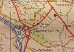
A contender for being the most unassuming piece of tarmac ever to hold status as one of the 'First 99' (rivalled only by the A88) the initial allocation of the A99 number belonged to three quarters of a mile of road just outside Stirling, which was constructed in 1974.
It started at Pirnhall Interchange on the then-A80, which marked the northern end of the M80 and southern end of the M9 Stirling bypass (that road would soon be extended in the direction of Falkirk to fill in the gap in the motorway). The A99 then ran northeastwards to the A9 at Greencornhills Roundabout in Bannockburn. Although an ostensibly temporary link between the incomplete motorway and the all-purpose route it was bypassing, it was always intended to be part of something greater, namely the Stirling Eastern Distributor Road, itself a bypass for Stirling and Bannockburn.
The A99 designation hung around until the remainder of the Eastern Distributor was completed in the late 1980s. The rest of the route was built from the northern end, with the crossing of the River Forth seeing the A91 extended to meet the A905 before the final connection to the A9 was completed at which point the A99 was renumbered as part of of the A91 and the A99 number fell into disuse for a short period before being revived in Caithness for an altogether different road.
This page includes a scan of a non-free copyrighted map, and the copyright for it is most likely held by the company or person that produced the map. It is believed that the use of a limited number of web-resolution scans qualifies as fair use under United States copyright law, where this web page is hosted, as such display does not significantly impede the right of the copyright holder to sell the copyrighted material, is not being used to generate profit in this context, and presents information that cannot be exhibited otherwise.
If the copyright holder considers this is an infringement of their rights, please contact the Site Management Team to discuss further steps.
