Star.pngStar.pngStar.pngStar grey.pngStar grey.png

A23

From Roader's Digest: The SABRE Wiki
Jump to navigation Jump to search
A23
Location Map ( geo)
Cameraicon.png View gallery (115)
From:  London (TQ311794)
To:  Brighton (TQ313038)
Distance:  52 miles (83.7 km)
Meets:  A302, B300, A3203, A3204, A3, A202, A203, A2217, A204, A205, B221, A214, A216, B272, B273, A235, A236, A232, B271, B275, A2022, A22, B2030, B2032, A237, B276, M23, B2031, A242, A25, A2044, B2036, A217, A2011, A2219, A2220, A2004, A264, B2114, B2110, B2115, A272, A2300, B2118, B2117, A281, A273, A27, A270, B2119, B2066, B2118, A259
Former Number(s):  A22
Primary Destinations
Highway Authorities

National Highways • Transport for London • Brighton and Hove  • Lambeth  • Surrey  • West Sussex

Traditional Counties

Surrey • Sussex

Route outline (key)
A23 London – Hooley
A23 Hooley – Pease Pottage
A23 Pease Pottage – Brighton

The A23 is the London to Brighton road.

Route

The southern end of the A23 at Brighton Pier
Main Article: A23/Route

Starting in Lambeth, it passes the various South London suburbs like Brixton, Streatham and Croydon before becoming non-primary at Hooley. It then goes though Redhill, passes Gatwick Airport and Crawley before resuming Trunk status at Pease Pottage Interchange before the run to Brighton where it ends on the Seafront on a roundabout with the A259. Part of the road is also in the South Downs National Park.

From its creation in 1936, the London-Brighton trunk road followed the A23 throughout its length.


History

The A23 at Handcross Hill in 1986
Main Article: A23/History

Unlike many of the First 99 that start in London, the A23's northern end has not really changed since Classification, although the section as far as Purley was originally numbered A22. The southern end has seen much more work. Today it is mostly D3 south of the M23 and an bypass of Crawley.

In 1956 to 1958 the A23 was rerouted around the east edge of Gatwick Airport which was being much expanded from the small prewar airport. Previously the A23 ran straight from Povey Cross to Lowfield Heath across where the airport is now.


Notable locations and improvements

Hooley Interchange

This is where the Northbound on-slip for the M23 would have been
Main Article: Hooley Interchange

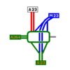
The Hooley Interchange is where the A23 finally loses trunk status to the M23. Due to the failure of the Ringway Project, today the M23 ends here instead of further north.


Gatwick Airport

The access point for the South Terminal at Gatwick Airport
Main Article: Gatwick Airport

Gatwick Airport has been a major destination for the A23 since 1935 with the original Beehive Terminal. It was upgraded in 1958 to become London's second airport. Today Gatwick is the world's busiest single runway Airport.


Handcross - Warninglid

Tree clearance - Handcross Hill

Main Article: A23/Handcross - Warninglid From Spring 2012 to October 2014, this winding D2 section was improved to modern D3 standard, and the Slaugham junction was closed, with improved junctions at Handcross and minor changes at Warninglid. Plans in the 1990s included a fourth lane up the hill northbound, though three lanes each way was chosen. Preparatory works started in October 2011 with the works finishing in 2014.


Patcham interchange

Patcham Interchange viewed from a near by house.
Main Article: Patcham Interchange

The Patcham Interchange is the last GSJ of the A23. Built in the early 1990's for the A27 upgrade, it is a poorly designed junction built into a small valley.


Opening Dates

Year Section Notes
1925 Patcham Bypass Mentioned as complete in a review of the year by the West Sussex Gazette of 31 December 1925. 0.4 mile.
1939 Crawley Bypass The 2.5 mile road opened on 9 July 1939, cost £200,000. Newspapers reported that road worker Thomas Sutton opened the road then went home for breakfast, but this was not true since there were 95 men working at the time and 3 sets of barriers to remove.
1959 Handcross Bypass New alignment with online dualling to Pease Pottage. Surrey Advertiser and County Times of 28 March 1959 reported that roadworks were nearing completion and it would open in July 1959. Work began in 1956-57. 1.1 mile with.24 foot carriageways.
1960 Pease Pottage Bypass Opened by Easter 1960. There were now 7 miles of continuous dual carriageway from Crawley Bypass to Bolney Common.
1986 Redhill Southern Relief Road Marketfield Way was opened on 20 August 1986. Cost £600,000.
1991 Sayers Common and Albourne Bypass Sayers Common - Muddleswood. Completed in December 1991 per Hansard. Contractor was Amey Construction Ltd.. Tender cost £10.5 million. Dual carriageway.
1992 Muddleswood - Patcham (Brighton) Online dualling. Completed in December 1992 per Hansard. Tender cost £15.4 million.
1993 Warninglid - Sayers Common Bypass Bolney Common Bypass and new alignment north of Bolney Crossways. Online dualling south of Bolney Crossways. Completed in June 1993 per Hansard. Tender cost £14.3 million, outturn cost £20.9 million.
2006 Coulsdon Relief Road Farthing Way was opened on 16 December 2006. The single carriageway road had one southbound lane and two northbound lanes, one being a priority lane for public transport, HGVs and cyclists. Contractor was Hochtief, cost £35 million.
2014 Handcross - Warninglid Widening 2.4 mile section realigned and upgraded from D2 to D3. Opened on 6 October 2014 per the Land Compensation Act notice. Included local access road, footpath and cycleway. Contractor was Carillion, outturn cost £78 million. See POPE Report.

Links

Roads.org.uk

Roads UK

National Highways


A23
Projects
Junctions
Airport Way Roundabout East • Airport Way Roundabout West • Albourne Junctions • Beaconsfield Crossroads • Beehive Ring Road Junction • Belfry Roundabout • Bolney Crossways • Bolney Park Farm Junction • Brighton Road Roundabout • Carden Avenue Roundabout • Cheals Roundabout • Crown and Anchor Junction • Dale Hill Junction • Ditchling Road Crossroad • Ewhurst Roundabout • Fiveways Corner (Croydon) • Fleming Way Roundabout • Gatwick Road Roundabout • Gossops Green Junction • Grand Junction (Brighton) • Handcross Junction • Hickstead Interchange • Hooley Interchange • Ifield Roundabout • Kennington Oval • Lombard Roundabout (Croydon) • Lombard Roundabout (Redhill) • Longbridge Roundabout • Lowfield Heath Roundabout • Manor Royal Junction • North Road • Old Steine • Open Market • Patcham Interchange • Pavilion Parade • Pease Pottage Interchange • Preston Circus • Preston Park South Junction • Purley Cross • Pyecombe Interchange • Richmond Parade • Sayers Common Junction • Slaugham Junction • Southgate Roundabout (Crawley) • St Peters Church • Streatham One-Way System • The Stations Roundabout • Thornton Heath Pond • Tushmore Gyratory • Warninglid Interchange • Westminster Bridge South
Services
Crossings
Roads
Places
Miscellaneous
Related Pictures
View gallery (115)
Pease Pottage Interchange.PNGM23 split at Hooley - Coppermine - 22226.jpgA23 Coulsdon relief road, bollards - Coppermine - 9947.jpgHooley revisited - Coppermine - 18102.jpgTushmore2.jpg
Other nearby roads
Central London
A Ring • A2 • A3 • A4 • A5 • A10 • A11 • A13 • A40 • A40(M) (Central London) • A41 • A100 • A200 • A201 • A202 • A203 • A215 • A300 • A301 • A302 • A303 (Vauxhall - Wandsworth) • A400 • A401 • A402 • A404 • A500 (Marble Arch - Finchley) • A501 • A1200 • A1202 • A1203 • A1204 (Wapping) • A1208 • A1209 • A1210 • A1211 • A1212 • A1213 • A2198 • A2200 • A2205 • A2206 • A2207 • A3036 • A3200 • A3201 • A3202 • A3203 • A3204 • A3205 • A3211 • A3212 • A3213 • A3213 (Pall Mall) • A3214 • A3215 • A3217 • A4200 • A4201 • A4202 • A4203 • A4205 • A4208 • A4209 • A4801 • A5200 • A5201 • A5202 • A5203 • A5204 • B100 • B101 • B107 • B126 • B128 • B129 • B130 • B131 • B132 • B133 • B134 • B139 • B144 • B200 • B201 • B202 • B240 • B300 • B308 • B309 • B310 • B310 (Thames Embankment) • B311 (Westminster) • B312 • B323 • B324 • B326 • B327 • B400 • B401 • B402 • B403 • B404 • B405 (Trafalgar Square) • B406 • B500 • B501 • B502 • B503 • B504 • B505 • B506 • B507 • B513 • B521 • B522 • B523 • B524 • CS1 • CS2 • CS3 • CS5 • CS6 • CS7 • CS8 • E1 (Old System) • E2 (Old System) • E5 (Old System) • Ermine Street • EuroVelo 2 • Great North Road • Holyhead Road • London Inner Ring Road • Longest Lane • M1 • M11 • NCN13 • NCN4 • RM3 • Watling Street
Croydon
A22 • A23(M) Provisional Allocation • A212 • A213 • A222 • A232 • A235 • A236 • A2022 • A2039 (Croydon) • B231 (Croydon) • B243 • B266 • B267 • B268 • B269 • B271 • B272 • B273 • B274 • B275 • B276 • B2030 • B2032 • M23 • Ringway 2 • T5 (Britain)
Gatwick Airport
NCN20 • NCN21 • A23(M) Provisional Allocation • A217 • B2036 • B2037 • M23 • M25 • POLO • T5 (Britain)
Crawley
Brighton
NCN2 • NCN20 • NCN288 • A27 • A259 • A270 • A277 (Brighton) • A2010 • A2038 • A2073 • B2066 • B2118 (Brighton) • B2119 • B2120 • B2121 • B2122 (East Sussex) • B2123 • B2137 • B2193 (Portslade-by-Sea) • C25 (Brighton and Hove) • C31 (Brighton and Hove) • C32 (Brighton and Hove) • C55 (Brighton and Hove) • C56 (Brighton and Hove) • C542 (Brighton and Hove) • C1060 (Brighton and Hove) • C2167 (Brighton and Hove) • C2400 (Brighton and Hove) • C2500 (Brighton and Hove) • C2666 (Brighton and Hove) • C4220 (Brighton and Hove) • C4500 (Brighton and Hove) • C4780 (Brighton and Hove) • C5060 (Brighton and Hove) • C5280 (Brighton and Hove) • C5360 (Brighton and Hove) • C5380 (Brighton and Hove) • C5600 (Brighton and Hove) • C5840 (Brighton and Hove) • C6000 (Brighton and Hove) • T5 (Britain) • T37 (Britain)
A1-A99
The First 99           A1  •  A2  •  A3  •  A4  •  A5  •  A6  •  A7  •  A8  •  A9  • A10 • A11 • A12 • A13 • A14 • A15 • A16 • A17 • A18 • A19
A20 • A21 • A22 • A23 • A24 • A25 • A26 • A27 • A28 • A29 • A30 • A31 • A32 • A33 • A34 • A35 • A36 • A37 • A38 • A39
A40 • A41 • A42 • A43 • A44 • A45 • A46 • A47 • A48 • A49 • A50 • A51 • A52 • A53 • A54 • A55 • A56 • A57 • A58 • A59
A60 • A61 • A62 • A63 • A64 • A65 • A66 • A67 • A68 • A69 • A70 • A71 • A72 • A73 • A74 • A75 • A76 • A77 • A78 • A79
A80 • A81 • A82 • A83 • A84 • A85 • A86 • A87 • A88 • A89 • A90 • A91 • A92 • A93 • A94 • A95 • A96 • A97 • A98 • A99
Motorway sectionsA1(M): (South Mimms - Baldock • Alconbury - Peterborough • Doncaster Bypass • Darrington - Birtley)
A3(M) • A8(M) Baillieston spur • A38(M) • A48(M) Cardiff spur • A57(M) • A58(M) • A64(M) • A66(M) • A74(M) • A92(M)
DefunctA1(M) Newcastle CME • A2(M) Medway Towns Bypass • A4(M) • A5(M) • A8(M) Renfrew bypass • A14 • A14(M) • A18(M) • A20(M) • A36(M)
A40(M): (Westway • Denham -Stokenchurch) • A41(M) • A42 • A46(M) • A48(M): (Port Talbot bypass • Morriston bypass) • A62(M) • A88 • A99
UnbuiltA2(M) Rochester Way Relief Road • A6(M): (Western route • Eastern route) • A14(M) (Expressway) • A34(M) • A48(M) Llantrisant Radial • A59(M) • A61(M)

SABRE - The Society for All British and Irish Road Enthusiasts
Discuss - Digest - Discover - Help