Guards Mill Interchange
| Guards Mill Interchange | |||
| Location Map ( geo) | |||
 | |||
| Next stop, Scotland | |||
| |||
| Location | |||
| Guards Mill | |||
| County | |||
| Cumberland | |||
| Highway Authority | |||
| National Highways | |||
| Junction Type | |||
| Half-Diamond | |||
| Roads Joined | |||
| M6, A74(M), B7076, A6071 | |||
| Junctions related to the B7076 | |||
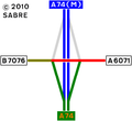
Guards Mill Interchange is junction 45 of the M6, marking the north end of that motorway and the southern end of the A74(M). It is the most northerly motorway junction in England and less than 400 yards south of the Anglo-Scottish border.
It is a half-diamond junction with south-facing slip roads, connecting the M6 to the A6071 and the B7076. Two former north-facing slip roads still exist, but are normally closed by gates at their south ends. From the motorway they are signed as a works unit, and the hard shoulder continues across their mouths.
History
The original full diamond junction was opened in 1973 as part of the A74 Gretna bypass, to connect it to a southward diversion of the A6071 which was built as part of the same contract. (Until then the A6071 ran through Springfield and Gretna Green.)
A D3 weaving section extended north along the bypass from this junction to the nearby A75 junction. Here, crossing the River Sark, which forms the Border, were the only 3-lane carriageways anywhere on the A74, except (in later years) for a southbound climbing lane immediately south of Millbank Interchange, which was at that time the southern terminus of the M74.
In the early 1990s, opening in December 1992, the Gretna bypass was upgraded to D3M standard to form part of the A74(M), with this junction becoming the southern terminus of that motorway. The junction bridge had to be replaced by a longer one on the same site; while this was going on, the A6071 was carried by a temporary Bailey bridge alongside. In order to remove weaving from the motorway, the north-facing slip roads were closed as described above, though additional slip roads were built nearby on the A74(M) and A75.
Between 2006 and 2008, opening 5 December 2008, the A74 southwards from the junction (the Cumberland Gap) was upgraded to D3M to become part of the M6. This required almost no physical change to the junction except for signs and road markings; it now became J45 on the M6. Strictly speaking the M6 ends at the slip road noses, so that the junction's bridge spans the A74(M), not the M6.
Occasionally locals try to get the north-facing slip roads reopened. For example the following written answer was made in the Scottish Parliament in September 2016:
Question S5W-02836: Oliver Mundell, Dumfriesshire, Scottish Conservative and Unionist Party, Date Lodged: 16/09/2016
To ask the Scottish Government what discussions it has had with the UK Government regarding the re-opening of junction 45 to northbound traffic on the M6.
Answered by Humza Yousaf (21/09/2016):
There have been no direct discussions between the Scottish Government and the UK Government. However there have been on-going discussions over a number of years between Highways England (formerly Highways Agency), Transport Scotland, Local Authorities and Community Councils. An initial meeting took place 13 April 2011 and subsequent meetings were held on 13 December 2013, 15 August 2014, 19 March 2015, 15 April 2016 with the latest held on 15 September 16. As the motorway junction is in England, this is essentially a matter for National Highways.
Routes
| Route | To | Notes |
| The SOUTH, Carlisle (A7) | ||
| SCOTLAND, Glasgow, Edinburgh Dumfries, Stranraer (A75) |
||
| Longtown | ||
| Glasgow, Edinburgh (A74(M)), Dumfries, Stranraer (A75), Gretna, Gretna Green, Springfield |
||
| Glasgow, Edinburgh, Dumfries, Stranraer (A75) | upgraded to A74(M) in 1992 | |
| The SOUTH, Carlisle (A7) | upgraded to M6 in 2008 | |
| Gretna, Gretna Green, Springfield |
Strip Maps

The layout as it was in 1980.
The layout as it was in 1993.

The current layout of the interchange.


_-_Geograph_-_319562.jpg)


