Kingstown Interchange
| Kingstown Interchange | |||
| Location Map ( geo) | |||
 | |||
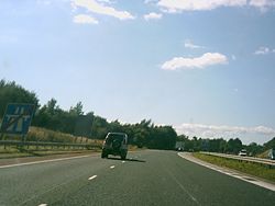
| The Kingstown Interchange going North in 2004. | |||
| |||
| Location | |||
| Kingstown, Carlisle, Cumberland | |||
| County | |||
| Cumberland | |||
| Highway Authority | |||
| National Highways | |||
| Junction Type | |||
| Roundabout | |||
| Roads Joined | |||
| M6, A7, A689 | |||
| Junctions related to the A689 | |||
Bradbury Interchange • Milton Junction • Cold Knot Roundabout • Wolviston Interchange • Brampton Roundabout • Newby West Roundabout • Orton Road Roundabout • Burgh Road Roundabout • Moorhouse Road Roundabout • Kingmoor Bridge (West) Roundabout • Kingmoor Bridge (East) Roundabout • Kingmoor South Roundabout • Kingmoor Hub Roundabout • Parkhouse Road Roundabout | |||
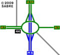
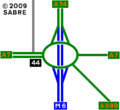
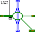
The Kingstown Interchange, also known as Greymoorhill Interchange, was for the first 38 years of its existence the northern terminus of the M6. It is a grade-separated roundabout, junction 44 of the M6, connecting it to the A7 and A689 north of Carlisle. It formerly also connected the A74, upgraded in 2008 to become an extension of the M6.
History
The interchange opened in December 1970 along with the rest of the Carlisle By-Pass section of the M6. At the same time the southern end of the A74 was diverted away from its previous route along Parkhouse Road (see below) to feed into the interchange as a dual carriageway continuation of the M6.
As seen by a northbound traveller, the 3-lane carriageways of the M6 narrowed on the right to become the 2-lane ones of the A74 immediately before the slip road from the roundabout joined on the left. Southbound, the carriageway widened on the left from two to four lanes, passed under a gantry sign, lost two lanes into the exit slip road, then widened on the right to three lanes.
From 1972 this interchange was at the end of a continuous 300-mile all-motorway route from London.
The north-eastern exit/entry to the roundabout, originally a minor road, was upgraded in 1994 to become part of the A689. A hint of the original T-junction between the A7 and the minor road can still be seen immediately north of the roundabout. This was the only previous junction on the site.
In the 1990s the gradual upgrade of the A74 to M74/A74(M) in Scotland made the section of A74 between here and Guards Mill Interchange seem increasingly anomalous, and it became known as the Cumberland Gap. By 1999 it was the only remaining non-motorway stretch of the route from London to Glasgow. Work began in 2006 to extend the M6 through the Gap, largely by on-line upgrading of the A74. On 5 December 2008 the Gap was abolished and this junction ceased to be the end of the M6.
Apart from changes to signs and road markings (including removal of the gantry), almost no alteration was required to the interchange as a direct consequence of the motorway upgrade. However, work was carried out simultaneously to widen and signalise the roundabout and its immediate approaches, and to alter its south-western kerbline in preparation for the future construction of the A689 Carlisle Northern Development Route (CNDR), which opened in February 2011.
The shape of the roundabout and the orientation of the junction bridges made it difficult to accommodate an extra road on the south side of the junction. The CNDR has been fitted in in a way that would not have been possible if the roundabout had remained unsignalised.
Parkhouse Road
At the same time that the interchange was built, a 400-yard stretch of A7 southward was dualled. The dual carriageway ends at the junction with Parkhouse Road, the original A74. This junction was once a simple sharp-angled at-grade fork, somewhat south of the present junction. At some time, probably in the 1950s, it was converted to an elongated roundabout in the angle of the fork. After the opening of the motorway interchange, Parkhouse Road was realigned along what had been the northern edge of the roundabout, to join the A7 at right angles at what is today a signalised junction. This left a triangular strip of grass where most of the roundabout had been. This area has since been partly used for car parks and a new building, housing a bank branch and fast food outlet, but it is still easy to deduce where the roundabout was.
Since 2008 Parkhouse Road has formed the southern part of a route for local and prohibited traffic parallel to the M6 between here and Guards Mill Interchange.
Routes
| Route | To | Notes |
| SCOTLAND, Glasgow, Edinburgh, Dumfries | ||
| The SOUTH, Preston, Penrith | ||
| Hawick, Galashiels, Longtown 8 | Tourist Route to Edinburgh | |
| Workington (A595) | ||
| Hexham, Brampton, Carlisle Airport, Houghton | ||
| Carlisle (North) | ||
| SCOTLAND, Glasgow (M74), Dumfries (A75), Edinburgh (A702) | upgraded to M6 in 2008 |
Strip Maps


