A4105 (Malvern)
| A4105 | ||||
| Location Map ( geo) | ||||
| ||||
| From: | Colwall Green (SO743403) | |||
| To: | Malvern (SO774451) | |||
| Distance: | 4.3 miles (6.9 km) | |||
| Met (1961): | A449, B4232, A449 | |||
| Former Number(s): | B4217 | |||
| Now part of: | B4218 | |||
| Traditional Counties | ||||
| Route outline (key) | ||||
| ||||
For the route in Cheltenham, a common misprint for the A4015, see A4105 (Cheltenham).
For the former route in Brimfield, Herefordshire, see A4105 (Brimfield).
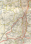
The original A4105 was a loop off the A449 (renumbered from A48 in 1935), providing an alternative route into Malvern from the Herefordshire side.
The road started on the A449 to the south of Colwall Green. It headed north into the village where it crossed the Hereford to Worcester railway line, then ran through Colwall Stone, climbing to reach the summit of the Malvern Hills ahead. On reaching Upper Colwall the road zigzagged, needing a couple of hairpin bends to lessen the gradient.
After a short multiplex with the B4232 the road reached its summit and crossed the ridge through the Wyche cutting. It then turned sharply left to begin its descent, which on this side was not as steep or as winding as the other side. However, the descent did not lose as much gradient as was gained either. The A449 had taken a more southerly, flatter route than the A4105 and presently the two roads met up again at a sharp angle, where the A4105 ended.
The road was originally numbered B4217. However, after the road was upgraded on the Herefordshire side in the 1920s to reduce the climb the road gained the A4105 number. In the 1960s, however, the road was downgraded again and is now numbered B4218 (the original number had been reused and was therefore not available).


