Star.pngStar.pngStar grey.pngStar grey.pngStar grey.png

A4165

From Roader's Digest: The SABRE Wiki
Jump to navigation Jump to search
A4165
Location Map ( geo)
Cameraicon.png View gallery (5)
From:  Oxford (SP511066)
To:  Kidlington (SP497123)
Distance:  3.7 miles (6 km)
Meets:  A4144, B4495, A40, A4260
Former Number(s):  A423
Primary Destinations
Highway Authorities

Oxfordshire

Traditional Counties

Oxfordshire

Route outline (key)
A4165 Oxford - Kidlington
Summertown

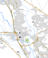
The A4165 heads north out of Oxford. The road was originally numbered A423.

The road starts at a fork at the northern end of St Giles, a wide road on the northern edge of the city centre. The A4144 has to TOTSO here, although that road has always had numerical priority at this junction.

The A4165 heads north along Banbury Road. Initially it runs amongst university buildings but we merge seamlessly into the leafy suburbs. Presently the B4495 is crossed at traffic lights. We continue through the attractive-sounding suburbs of Summertown and Sunnymead (on the ground they could be anywhere) and eventually we reach a roundabout on the A40 ring road. We continue north past a cemetery and enter open country.

The road runs between a golf course and open fields before traffic lights provide access to the Water Eaton park & ride site. The road then goes over the Oxford to Bicester railway line and the A34 (without a junction) before reaching a roundabout on the original line of the A43, which is now the A4260 to the left and unclassified to the right. The former continues ahead into Kidlington and so the A4165 ends here.


A4165
Junctions
Roads
Places
Related Pictures
View gallery (5)
Green light to go - Geograph - 1705795.jpgBanbury Road - Geograph - 551602.jpgParting of the ways, St Giles - Geograph - 720678.jpgCutteslow Roundabout grade separation.pngOxford Inner Relief Road 1968.png
Other nearby roads
Oxford
NCN51 • A34 • A40 • A42 (Reading - Birmingham) • A43 • A44 • A420 • A423 • A4074 • A4141 (Oxford) • A4142 • A4144 • A4158 • A4260 • B480 • B4014 (Oxfordshire) • B4027 • B4150 • B4495 • B4496 • E05 • Longest Lane • M40 • Oxford Ring Road • T10 (Britain) • T13 (Britain) • T42 (Britain) • T47 (Britain) • T114 (Britain)
A4100-A4199
A4100 • A4101 • A4102(W) • A4102(E) • A4103 • A4104 • A4105 • A4106 • A4107 • A4108 • A4109 • A4110 • A4111 • A4112 • A4113 • A4114 • A4115 • A4116 • A4117 • A4118 • A4119
A4120 • A4121 • A4122 • A4123 • A4124 • A4125 • A4126 • A4127 • A4128 • A4129 • A4130 • A4131 • A4132 • A4133 • A4134 • A4135 • A4136 • A4137 • A4138 • A4139
A4140 • A4141 • A4142 • A4143 • A4144 • A4145 • A4146 • A4147 • A4148 • A4149 • A4150 • A4151 • A4152 • A4153 • A4154 • A4155 • A4156 • A4157 • A4158 • A4159
A4160 • A4161 • A4162 • A4163 • A4164 • A4165 • A4166 • A4167 • A4168 • A4169 • A4170 • A4171 • A4172 • A4173 • A4174 • A4175 • A4176 • A4177 • A4178 • A4179
A4180 • A4181 • A4182 • A4183 • A4184 • A4185 • A4186 • A4187 • A4188 • A4189 • A4190 • A4191 • A4192 • A4193 • A4194 • A4195 • A4196 • A4197 • A4198 • A4199
Former iterations: A4105(W) • A4105(E) • A4108 • A4114 • A4115 • A4116 • A4125 • A4141 • A4150 • A4154 • A4160 • A4168


SABRE - The Society for All British and Irish Road Enthusiasts
Discuss - Digest - Discover - Help